 What does a Greenstone/Mesothermal shear zone hosted Mineralization deposit look like? Well they usually comprise one or more steeply dipping quartz or carbonate rich veins, as you can see in the pictures these sometimes forms veins or even stock works of narrow vein. Mineralization is regularly distributed in the vein often forming steeply plunging high grade. All rock alteration is seldom visible to the naked eye for more than a few meters away, from the vein margin.
Although a subtle geochemical halo can be detected instruments many hundreds of meters away from the veins. The amount of sulfide in the vein varies from almost none up to twenty percent. Common sulfides include pyrites and Oceania pyrites, with a lesser amounts of arsenopyrite to continually ride minerals. Gold is usually fairly finely disseminated and it is seldom visible to the naked eye. But sometimes it is and you’ll see a lot of prereleases put out by juniors to give permanence to visible gold having been observed in drill holes.
This is actually really not significant as it give little clues to the grade, it only shows that there is a high negative effect. High grade are likely to be very variable. You’ll also sometimes hear the word refectory apply to gold ore. This usually means that the gold particles are locked up in sulfide grains. And you need to oxidize does sulfide grains in a red still or autoclave to another gold coming to contact with the devolving cyanide solution.
Arsenopyrite is commonly the culprit in a refractory gold ore. In evaluating a shear and host gold deposit, we need to see that those good grade, that the veins are continuous and not trapped up by later Structures and that they have sufficient width to allow economic mining.
So what do we need to form one of these greenstone shears hosted gold deposits? Let’s take a moment to review what we have covered so far. First we need an Archean craton to provide the deep source of gold. I believe that even in the cases, Proterozoic Greenstone/Orogenic belt, the gold is often sourced from underlined the Archean crust.
Secondly we need a major tectonic event to thicken the crust and trigger partial melting of the deepest portion. I.E we need structure. Thirdly we need the crustal scale fault where usually a package of thrust faults to allow the gold in riches to rise towards the surface, again structure. Fourthly we need a trap to form a structure in a form of structural damage zone or location that will allow the gold to variant fluid to mix with shallow sourced to reduced groundwater.
So you can see how structure pays the pivotal role in the development greenstone belt shear zone hosted gold deposit. And it make sense for me to talk a little bit more about how greenstone belts form and how this controls the mineralization.
I put together a series of cartoons on a long and boring flight to illustrate this process. Obviously this is being generalized individual Greenstone/Orogenic belt varies slightly with various stages often being aborted or even repeated. But the overall pattern seems to hold true cratons across the globe whether Archean or lower Proterozoic.
The process starts with some of the earlier continental crust formed on earth. 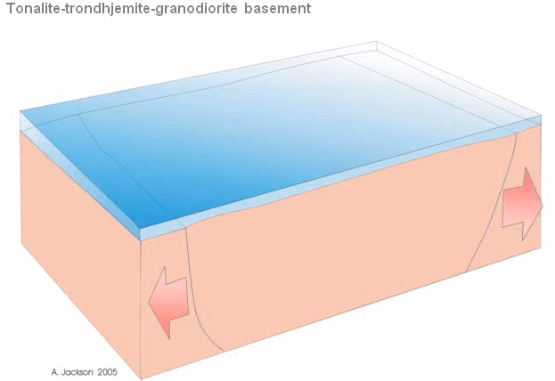 This crust consists of granite like rocks call tonalite, trondhjemite or granodiorite. And they provide the basement on which the greenstone belts will laid down. As the crust cool beneath the ocean they contract it and develop extensional faults. Theses faults allow blocks and the basement rocks to collapse to form gravies.
 Mafic and ultramafic magma from the underline mantle took advantage of the deep faults and were injected up the faults and on to the sea floor.
There they erupted and spread out under the sea in similar way to what is happening today in the mid oceanic ridge spreading centers. Filling the graven with ultramafic lavas.  As time went on, the magma chambers feeding the volcano differentiated to become more intermediate in composition and the basalt gave way to andesitic lavas.
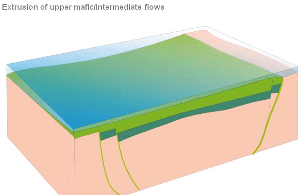
Eventually the magma chambers differentiated to the point where results in magma became granitic. Magmas have a Granitic composition a far more viscous than the fluid mafic and the ultramafic magmas that were originally produced.
Instead of flowing on to the sea floor, they started melting the basement forming large catalytic intrusions.
Pulse after pulse of granites enlarge the intrusions until the magma interrupted to the surface, building up domes of pyrites and felsitic lavas and para plastics. And these were pushed up above sea level.  Throughout this whole process the original basement fault, kept on being reuses and remobilized. The felsic volcanic domes continued to grow and because they are now above sea level they became subject to erosion by river and rain.
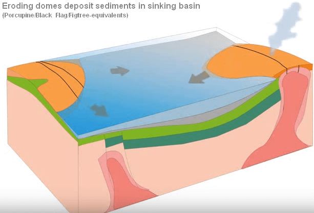
The product of this erosions collected in the basins between the domes and the built up thousands of feet of sediments. The weight of accumulating sediments causes the faults along the margin of the basin to reactivate and the basins continue sinking allowing further sediment to accumulate.
 Not only the basin sink but the hot basement material that was forced down, escape sideways adding material under the granite domes, further inflated them and steeping the slopes between the rising domes and the sinking basins.
 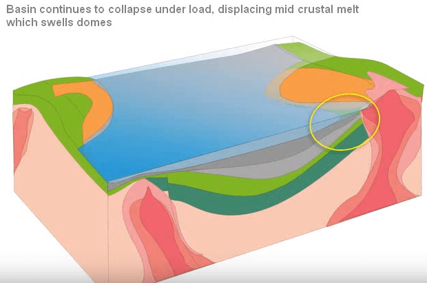 Eventually those slopes became too steep for the volcanic and the sedimentary resists to pull gravity, in large part of the stratigraphy detach long flat, bedding parallel faults and slipped into the basins.
 You can see exactly the same features forming today along the margins of contents, where the failure often occurs along weak salt bed or over pressure I shale. In the Archean Greenstone/Mesothermal belts failure often occurs along conformations or ultramafic flows.
 As he slam, slips into the basins, the road on the detachment faults and bulldoze the sediments ahead of them into a series of anti-cling and synclines that forms tens of kilometers into the basin. The cost and poorly sorted material from these landslides ended up being deposited into smaller basin or half graben develop around the domes.
 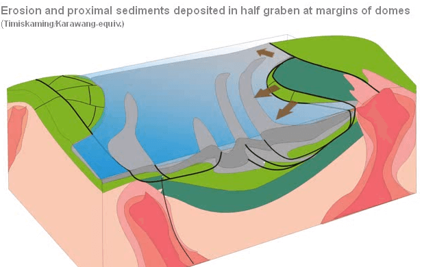 There they form bridges of con-glimmers and grey Rockies, sandwiched between the granites and mafic volcanic in the domes and the grey sediments in the filling the basin.
In Canada you’ll hear these deposits refer to as the Timiskaming types of elements. Now up until this time dominate forces have been vertical tectonic driven by differences and density between hot light granitic magmas in the domes and cool dense mafic and intermediate volcanic, filling the basins. How do you explore for such a deposit? This cause the basins to sink and the domes to be push up, but at the end of the Archean, this change and the world wide phase of horizontal tectonics, precursor of the onset modern or plate tectonic as we know today, were suddenly initiated.
 This major phase of horizontal shortening, squeeze the domes and cause faulting and thrusting and final injection of the felsic porphyry dikes in small intrusions. Into both and these were injected both the domes and newly form thrust faults. These small late-stage felsic porphyry intrusions, maybe the products of the partial melt in the deep crust that was triggered by the onset of that horizontal compression and resultant crustal thickening. Now up until this compression there have been very little significant gold mineralization but the intrusion of these felsic porphyries always seems to closely precede the main pulse of gold mineralization.
The main gold mineralizing event usually took place just after peek metamorphism and deformation. If you remember from earlier in the talk, the best way to get gold to drop out of solution is to drop the EH by mixing the hydrothermal solution with reduced ground water from a carbon rich shale. And you can see clearly how this might have happened. As the basins were been squeezed and cooked up by the horizontal shorting the water from the shales was expelled taking advantage of newly formed thrust faults.
Some of this reduce water was simple expelled on to the seafloor but some of it was also forced back towards the margins of the domes, where it make gold bearing oxidize magmatic fluids. This occurred around the late felsic intrusions. Most common sites for the conformation of Greenstone/Orogenic shears and hosted gold deposit is in these major crustal scale fault zone.
That cut across the craton for hundreds of kilometers, following the junction between the granite and bastille of domes and the old sediment fill basins. Very often associate with late stage to miscuing equivalent sedimentary units.  And the felsic porphyry intrusions. Once all the compression ended the erosion took over and the entire area was plain down to the view that we have today.
So what are these major crustal scale faults look like today? Here is a geological map of the Timmins area in Ontario. A typical Greenstone/Mesothermal type terrain and that covers about a hundred kilometers from east to west. The major controlling structure is the porcupine destroy faults. It separates the granite and basalts of one of these domes to the south, from the grey sediments filling the basins of the north. The fault Cohen side into basins with a Timiskaming sediment are colored in chocolate brown on this map.
The faults also shows up a magnetic image. You remember that I mentioned bend or jugs in the faults have been favorable places for gold traps. The huge Alex McIntyre and dome mines are located at the middle of the biggest bend on the porcupine destor fault zone.
