In earlier years, the custom prevailed of regarding the anthracite basins as cases of folding with slight development of faulting. Folding is so pronounced and, in the eastern and western Middle Fields, at times so violent, that the inference was a natural one and led to the widespread impression that practically all the disturbances of the seams could be explained in this way. The cross-sections and maps prepared forty or more years ago for the Second Geological Survey of Pennsylvania, by Mr. Ashburner under Prof. J. P. Lesley, exhibit little else than folds. So far as I can discover faults fail in the charts, except in one small case in the Henry Colliery near Plainsville on the outskirts of Wilkes-Barre.
Some years ago, while spending a day or two in Wilkes-Barre, under the guidance of R. V. Norris, I looked over some recent and accurate cross-sections of a number of the large collieries and was deeply impressed with the peculiar behavior of some of the seams and the intervening shales. Thus, a seam might present a small, more or less overturned fold, rising 30 to 50 ft. (9 to 15m.) above, its general  course, and yet the movement would be taken up in the overlying shales, so as hardly to be noticeable in the seams next above or below. These and similar anomalies, especially when shown with the accuracy of engineer’s surveys, possess great scientific and practical interest, bearing as they do, not alone on coal mining, but on theoretical geology and the actual behavior of strata under great compressive stresses. In preparation for the semicentennial meeting of the Institute, an effort was therefore made to secure some of the most interesting sections for presentation to the members. The collection of illustrations here shown is mainly due to Mr. Douglas Bunting of the local committee, to whom and to the contributing companies acknowledgments are due.
The illustrations are taken from all four of the main basins, but are chiefly from the portions nearest Wilkes-Barre. The first are in the southern part of the Northern, or Wyoming, basin. The general geological section is as follows:
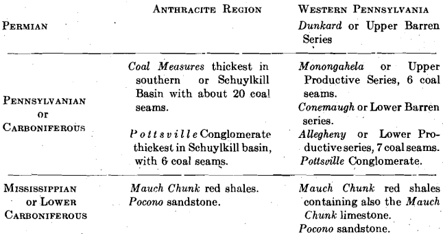
The subdivisions of western Pennsylvania cannot be easily carried out in the anthracite basins, and correlation of the strata must be made chiefly by comparative study of the fossil floras of the seams, as has been in progress by Dr. David White. A stratigraphic feature of much importance relates to the present, or former more extensive, existence of Permian strata in the anthracite areas, because on this question and the determination of the section that has been removed by erosion, depends the amount of load carried by the anthracite coal measures when they were folded. The folds and overthrust faults are characteristic of relatively small load. Moreover, individual small folds often become larger and larger as we approach the surface from the deep workings, just as if, with diminution of load, more extensive movements and adjustments became possible.
NORTHERN, OR WYOMING, FIELD
The first section, Fig. 1, is taken at the Auchincloss colliery on the southeast side of the Wyoming basin. There are 17 or 18 seams in the section, the number depending on the splitting into two of what would otherwise be a single seam. The names of the seams from the surface downwards are as follows: Nos. 6 to 10 inclusive; Top George; Bottom George; Abbott; Mills; Hillman; Baltimore; Top Forge; Forge; Top Twin; Bottom Twin, which splits into two on the left; Ross; Red Ash. With some local variation these names will be found on the other sections from this field; the Baltimore seam is generally believed to be the correlative of the Mammoth in the other three fields. On the right-hand side, the tendency of a fold, small in the lowest seam, to expand to greater proportions above is well illustrated, and the same tendency is shown in the large central anticline, which is overturned below, but grows broader and less violent above. The bulging of the shales and shaly sandstones and their tendency, by adjustment, to take up the displacement is well brought out. The splitting of the Bottom Twin seam and the double names for the George, the Forge, and the Twin, show the difficulty of correlating seams, even in adjacent properties. Unless actual workings are connected, uncertainties often arise. The thickening and thinning of the Baltimore seam are very apparent.
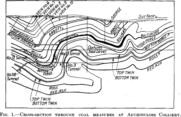
Fig. 2 is taken at Nanticoke about 8 mi. (12.9 km.) southwest of Wilkes-Barre. The right-hand half of the section reveals only slight disturbances, but the tendency of a small anticline below, to expand above, may be noted. At the surface is shown the old preglacial channel, which was buried in water-bearing sands and gravels and the unexpected presence of which led to the sudden rush of water, sand and boulders into the workings in the Ross seam, Dec. 18, 1885.
In the left-hand portion are two small overturns with steep dips facing to the left, which can be traced upward through several seams, from right below to left above, at angles of 15° to 30°. The great point of interest, however, is the thrust-fold at the extreme left, which, beginning as a comparatively small overturn in the lower seams, develops at the horizon of the Cooper (the local name apparently for the Baltimore) into a strong thrust fault, with a displacement on the 25° dip, of 600 ft. (182 m.). The Forge seam 75 to 100 ft. (22.9 to 30.5 m.) below is apparently not affected; and above it, the compressive strain was taken up in the adjustment of the shales with the great fault displacement mentioned. A second sympathetic overturn is shown still farther to the left, but with small breaks. The opposing dips of the axial planes of the folds and fault last described to those of the small ones farther to the right indicate that the two sets were produced by successive thrusts at different times.

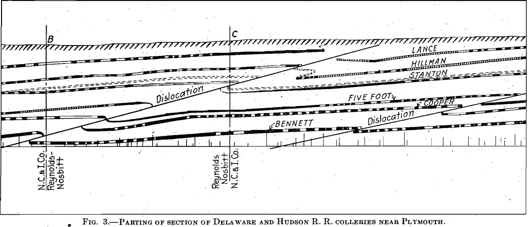
Fig. 3 is part of a much longer section of the measures near Plymouth, in the collieries of the Delaware and Hudson R. R. At the right-hand side, a small thrust fault with a dip of 12° is shown. The main thrust fault farther to the left has a dip of 15° and produces in the Lance, the uppermost seam of the section, a displacement on the dip of 150 ft. (45. m.). A displacement of 240 ft. has been suffered by the five-foot seam, which is 235 ft., vertically lower in the section; whereas the Bennett, 130 ft. vertically below the five-foot, has been displaced only 65 ft. Bulging and adjustment of shales are responsible for these
differences.
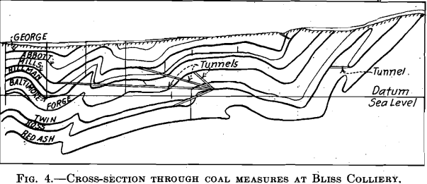
In the section at the Bliss Colliery, Fig. 4, at the right-hand side, the Red Ash and the Ross seams are affected by an overthrust N-shaped fold with
a very steep dip of the axial plane to the left. The bulging of the shales has been such that a sharp trough in the upper, or Ross, seam is brought directly over a sharp arch in the lower Red Ash. If a winze had been sunk from the bottom of the Ross seam trough in the natural expectation of finding a corresponding trough in the Red Ash below, it would have met an arch at less than half the normal interval! Farther to the left are two small overturns. The first is marked in the lower three seams and then is lost in a larger gentler fold above. The second is relatively small in depth, but with decreasing load at the time of folding, becomes larger and larger as we go toward the present surface.
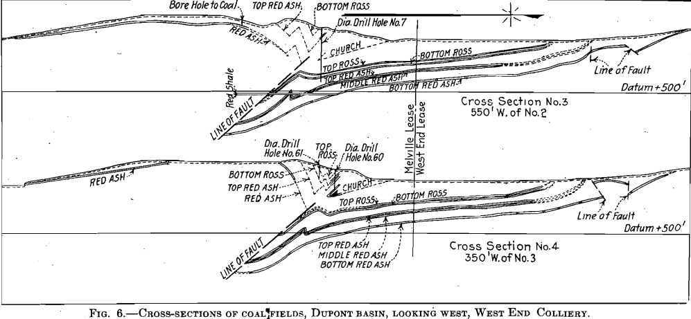
In the section at the Priscilla Lee basin of the West End Coal Co., Fig. 5, an extremely interesting instance of a greatly eroded anticline and accompanying thrust fault is shown. On the right, a drill hole at the end of the “No. 9 Projected Tunnel” revealed red shale with 3 ft. of shelly coal. This would imply that the Mauch Chunk shale, with a
dragged in block of sheared coal was faulted up opposite the Coal Measures. Yet the actual mining had shown the Bottom Red Ash seam 300 or 400 ft. immediately below. The Mauch Chunk shale must thus lie ahead of these workings. Finally, the existence of a great thrust fault is further demonstrated and its displacement amounting to 930 ft. is proved because the upward-thrust part of the Bottom Red Ash seam has been developed near the surface. After this upfaulted portion of the Bottom Ash seam had been traced to the left, it ran out to daylight because of erosion, but still farther to the left it was found preserved with the three next overlying seams in a small, outlying syncline.
In Fig. 6, additional details of the great thrust fault are brought out, and the excessive crumpling of the coal seams in the hanging wall close to the fault is illustrated. Farther to the left, the flat and undisturbed attitude of the Bottom Red Ash seam is one of the impressive structural features of the section. The strain was eased by a limited localized readjustment.
The northern, or Wyoming, Field from which these six illustrations have been taken is, on the whole, the least violently folded of the four main fields. The sections, however, make apparent that it has suffered from severe compression and that the easing of the strain has at times involved thrust faulting of great extent.

EASTERN MIDDLE FIELD
Fig. 7 is a section at Audenried. In this field, the local names for the seams are different from those applied near Wilkes-Barre. From the surface downward they are as follows: The Mammoth, which is a double seam, Wharton, Gamma, Buck Mountain, and Lykens. In the central part of the figure, despite the general, apparently gentle folding, the Lykens seam is upthrust until it is opposite the Wharton, having moved upwards 500 to 600 ft. on the plane of the thrust.
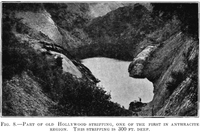
Fig. 8 shows not only a remarkable folded structure in the foreground, with its sharp syncline in the center and small roll on the right, but also, in the background near the top, a remarkable fault that must have involved an extended shift nearly parallel with the strike. In the pit in the foreground with the water, the coal was in place on both sides of the syncline. The coal was also in place on the right-hand side of the syncline, when followed into the extension of the strippings in the background; but on the left-hand side, where the straight bare wall of rock appears, the coal was missing.
WESTERN MIDDLE FIELD
In this field there is another change in the names locally applied to the seams. In the strikingly symmetrical syncline on the right in Fig. 9

fifteen seams are shown; their names, from the surface downwards, are as follows: Interval to surface, 200 ft. Spohn; interval 30 ft., Little Tracy; interval 70 ft., Big Tracy; interval 40 ft., Diamond; interval 50 ft., Orchard; interval 135 ft., Primrose; interval 45 ft., Little Primrose; interval 75 ft., Holmes; interval 35 ft., Four-foot; interval 120 ft., top split of Mammoth; interval 100 ft., bottom split of Mammoth; interval 45 ft., Skidmore; interval 65 ft., Seven-foot; interval 80 ft., Buck Mountain; interval 50 ft., Little Buck Mountain. These intervals vary in different places but the figures give a good working idea of the section of about 1100 ft. appearing in the figure. In the syncline the Mammoth seam has two splits about 100 ft. apart. The Top Split scales on the large section 18 ft. of coal; the Bottom Split 26 ft. As we follow them to the left-hand portion of the section they almost unite; then part and finally almost reunite.
As the large syncline on the right rolls over into its complementary anticline, a thrust fault has displaced the Buck Mountain seam about 550 ft.; but the overlying Seven-foot extends farther to the left and stops opposite the Primrose. In the adjustments of the shales under the compressive strains, the interval between the bottom and top splits of the Mammoth seam is greatly increased on the hanging-wall side of the fault. To the left of the fault, the two splits of the Mammoth and the Skidmore are affected by a slight thrust fault, which is not shown in the Seven-foot, next below. Still farther to the left, the two splits of the Mammoth are thrust-faulted about 80 ft. without affecting the Skidmore, next below. Farther to the left, a great thrust fault involves a displacement of about 1000 ft. in the Buck Mountain seam, the higher seams having been eroded from the hanging-wall portion.

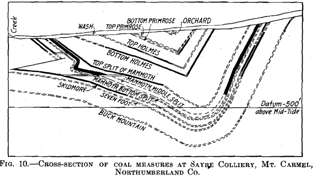
In Fig. 10, a sharp localized thrust is shown on the left-hand side of the syncline, which only produced a Z-shaped roll in the middle and bottom splits of the Mammoth seam, without breaking the continuity, but which displaced, by an overthrust fault of 400 ft., the Skidmore seam 75 ft. lower in the section. Bulging and adjustment of shales have taken up this thrust of 400 ft. without transmitting it appreciably to the top split of the Mammoth.
In Fig. 11, the north limb of a syncline is shown in which an overturned fold has parted in a thrust fault with an unusually steep dip of 50°. While such data as we have indicate that the lower four and relatively thin seams have been rather sharply cut off, the Mammoth seam, here about 40 ft. thick, has been turned and dragged up the foot wall of the fault for 200 ft. Above the Mammoth seam on the foot-wall side of the fault, a huge bulging of the shales has been produced, increasing the normal interval of about 200 ft. between the Mammoth and Holmes seems to fully thrice this amount.
SOUTHERN FIELD
An increased thickness of the geological section, together with sharply compressed, deep synclines, characterizes the Southern Field. The sections shown are at the eastern end. In Fig. 12, viewed as a whole, two somewhat complex synclines are separated by the very sharp, broken, upright anticline in the middle of the diagram. About 950 ft. of strata are involved. The extreme squeezing and forcing upward of the Seven-foot, Mammoth, and Primrose seams are very marked when compared with the lowermost Buck Mountain. Apparently some rupturing at the crest has also taken place, but exploration has not yet shown whether the two ends of the Mammoth seam will join or not. In the next subsidiary anticline on the left, there is an equally marked dragging upward of the
Holmes seam, whereas the Mammoth is but slightly affected. In both cases much adjustment has taken place in the associated sediments. In the first case, the Seven-foot seam is pinched and dragged nearly 700 ft. above the Buck Mountain, and in the second the Holmes has reached a point nearly 800 ft. above the lower or main split of the Mammoth. The two intervals in the normal section seem to be about 125 ft. and 75 ft., respectively.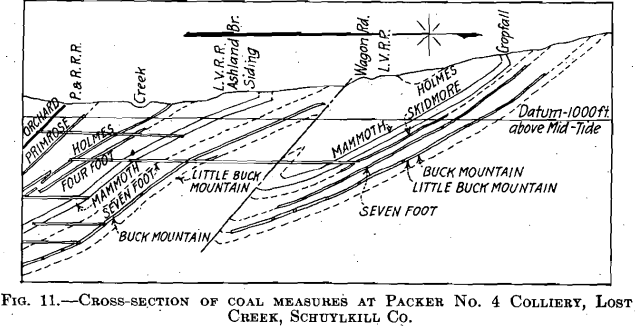
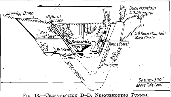
In Fig. 13, there are three interesting points. The small tight syncline in the upper right-hand marks the, survival after erosion of a sharply compressed extension of the main trough. In the latter, the peculiar roll of the Mammoth seam is worthy of study. At the left, a small and quite independent roll in the Buck Mountain seam has increased the interval between it and the Seven-foot from 160 ft. to 360 ft. The constant surprises which local structures of this sort bring to the mining engineer may well be remarked in passing.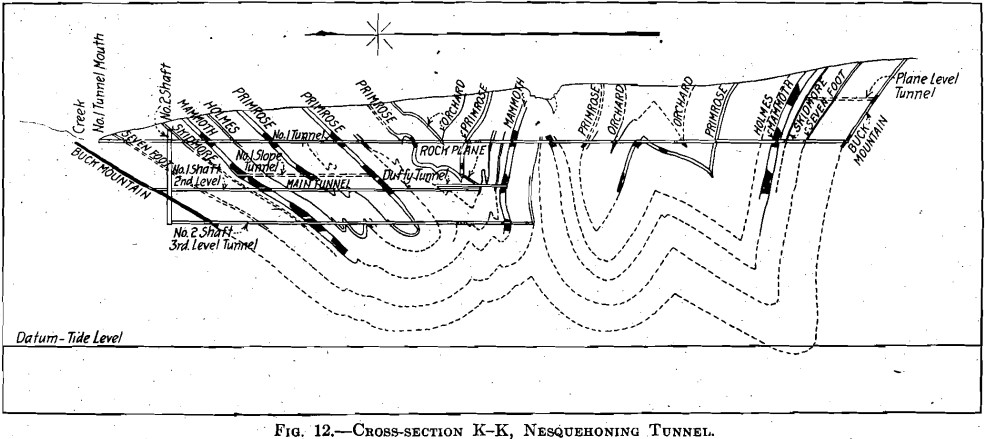
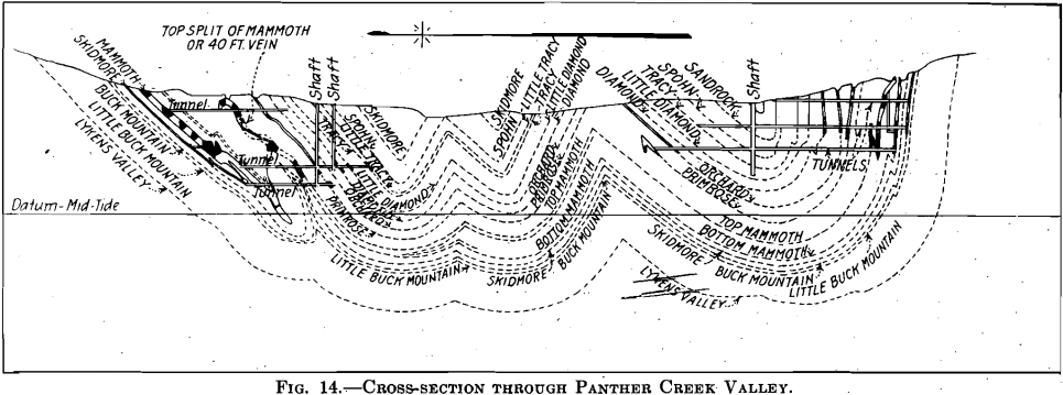
In Fig. 14, a very peculiar little thrust fold with a doubling of the Mammoth seam on itself is shown on the extreme right. This little tight fold extends over 360 ft. of vertical distance. On the lowest tunnel, 600 ft. north (or to the left) a small fold is shown in the Diamond, Little Diamond, Tracy and a very slight fold in the Spohn seam. Small as it appears in the illustration, this fold has increased the interval between
the Orchard and the Diamond from about 130 ft. on the tunnel above, to about 225 ft. in the third tunnel. The most interesting feature, however, is the pinching and stretching of the Mammoth seam in the last anticline on the left. After it was pinched together, the Mammoth seam was stretched up vertically over 600 ft. In the complementary syncline on the left, it is pinched and stretched downward nearly 400 ft. There are other peculiar features in the molding and thickening of the Mammoth seam in the northern limb.
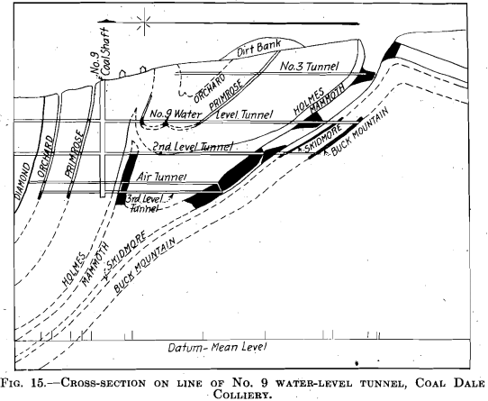
In Fig. 15, about 650 ft. of strata are involved with seven seams. A remarkable anticlinal bulge and thickening with upward stretching of nearly 600 ft. have been produced in the Mammoth seam, and have, influenced the four above it, but in so far as the inferred position of the two below are concerned, they are but slightly affected.
In the oral presentation of this paper, additional sections were shown as greater latitude was possible with lantern slides than is the case with
the engraved figures. But the ones reproduced here serve to bring out the main features. The existence of thrust faults of a displacement to be measured on the dip of as much as a 1000 ft. is the most important structural feature brought out. The tightly compressed and stretched folds, although more generally familiar, can never fail to be an object of interesting study to the geologist concerned with mountain-making
processes. Where they can be illustrated from the engineers’ surveys of the mines, they have an exact quantitative character of extreme value to the investigator. Some of the features commented upon, cannot fail to suggest the conclusion that the anthracite measures did not rest under a great load when they were folded, but that they were fairly free to break and slip by, when strained beyond a moderate ability to resist.
