Table of Contents
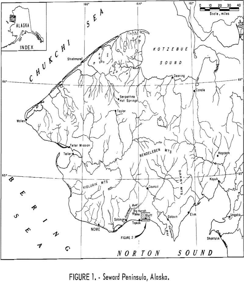
Placer and lode gold deposits near Bluff, Seward Peninsula, Alaska (fig. 1), were investigated during July and August 1966. The primary objective of this Bureau of Mines investigation was to sample a typical gold lode deposit as a basis for estimating the potential economic value of the lode sources of the productive Seward Peninsula gold placers. The gold lode deposits at Bluff are thought to be typical of the lodes from which many of the Seward Peninsula placer-gold deposits were derived. This report describes the placer and lode deposits in the Bluff area; it includes data on placer production, lode sample and spectrographic analyses, and petrographic descriptions of associated minerals and rocks.
The secondary objective was to test a systematic procedure for delineating and sampling typical gold lode occurrences in permafrost areas with simple equipment. The methods used are explained briefly in this report. These methods were developed during tin investigations in the western Seward
Peninsula, and are described in detail in Bureau of Mines Report of Investigations 6737, “Tin-Lode Investigations, Cape Mountain Area, Seward Peninsula, Alaska.”
Location and Access
Bluff (latitude 64°34′ N, longitude 163°45′ W) is a dormant mining camp 50 miles east of Nome on the south coast of the Seward Peninsula, Alaska (fig. 1). It is in the center of an uninhabited coastal area extending 40 miles from Golovnin Bay to Solomon. The Bluff area is readily accessible by light bush planes from Nome, the distribution center for the Seward Peninsula. Nome is served by daily scheduled flights from Anchorage and Fairbanks. The airfield at Bluff is on a metalimestone knoll; it has two runways, 700 feet long and 1,000 feet long, both marked by oil drums, and is used by bush planes that carry up to 1,000 pounds of cargo. Freight too heavy or bulky for air transport can be landed from ships on nearby beaches. No docks or freight-handling facilities are available; vessels are beached and unloaded on the sand. Eskimo skin boats capable of carrying up to a few tons, ordinary barges of 50 to 200 tons burden, and military-type landing craft have been used successfully.
During the project, a rubber-tired tracked vehicle was driven from Nome to Bluff and return via the Nome-Council road and connecting trails. Several routes were followed between the road and Bluff including one from Solomon along the coast to Topkok then along the ridgetops to Bluff airfield; one from Big Hurrah Mine east to Bluff airfield; and one from the head of the east fork of Solomon River to Bluff airfield. None of the routes presented serious obstacles, but steep slopes and swampy gulches east of Big Hurrah Mine make this the least desirable route.
Persons planning to work or visit in the Bluff area should make prior arrangements with the owners of the buildings and of the placer and lode claims. Although there has been little mineral production in recent years, claim owners maintain title to both buildings and claims. Some of the buildings are part-time residences and warehouses of groups prospecting for under-sea deposits.
Climate
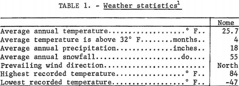
The climate of the Bluff area is subarctic tempered by the adjacent of Norton Sound and the Bering Sea that prevent both extremely high and extremely low temperatures. On Golovnin Bay, 20 miles east of Bluff, usually breaks up about May 20 and freezeup occurs between October 20 and November 2. Weather statistics for Nome, 50 miles west of Bluff, are shown in table 1.
Living Conditions
Modern communications and transport facilities have practically eliminated the isolation of the arctic and subarctic areas. Small communities and field parties in the southwestern Seward Peninsula communicate with Air Force Communication Service (ACS) stations in Nome by radiotelephone. Food, clothing, and hardware are stocked by stores in Nome. Supplies, repair parts, and perishable food can be delivered by plane as required. Items not available locally can be ordered by telephone or telegram and obtained by air in a few days from distributors anywhere in the United States.
Sturdy insulated houses are essential during the winter, but tents or light uninsulated houses are adequate for summer use. A common expedient is to mount a light cabin or tent on skids (locally termed a “wanigan”) and tow it about with a tractor as needed. Ordinarily, dwellings are heated by oil stoves, and cooking is done with either oil, bottled gas, or gasoline stoves.
Property and Ownership
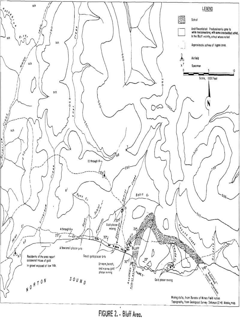
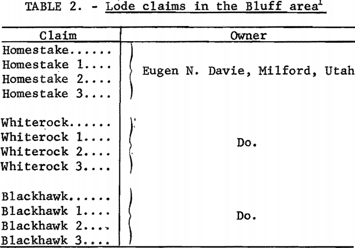
The twelve lode claims listed in table 2 blanket the Bluff schists from the seacoast east of Bluff almost to the head of Daniels Creek (fig. 2). These claims cover the same area included in the Eskimo, Idaho, and Sea Gull groups of claims and described in U.S. Geological Survey publications. Some of the claim stakes for this earlier group of claims remain legible and are dated 1900. No other lode claims were known to be in force, although numerous claim stakes were seen. Detailed title search was not made; investigation of claim ownership was limited to the minimum necessary to avoid unintentional trespass.
The owners of all placer claims and marine leases known to be in force in the area verbally granted access to sample lode deposits. No attempt was made to map the numerous stream placer claims, beach claims, and marine leases.
History and Production
Gold was discovered on the beach at the mouth of Daniels Creek (fig. 2) in 1899; the beach deposit was practically mined out during the following year. The lode deposits were discovered and staked in 1900, and work started on the placer deposits of Daniels Creek and nearby creeks. During the next few years consolidation of holdings and construction of an extensive ditch system brought water to Daniels Creek; this made hydraulic mining feasible. Daniels Creek was considered to be substantially mined out by World War I. From then until the early 1930 is little gold was produced. Swede Creek was mined from 1918 until World War II, and other creek and beach placers in the area were prospected and mined sporadically.
During the 1930’s an effective, but expensive, method was developed for mining high-grade placer concentrations that were below sea level in Daniels Creek and could not be mined hydraulically. The same method was then modified to mine the continuation of the Daniels Creek pay streak under the waters of Norton Sound. The method used a 6-inch self-propelled churn drill to precisely locate high-grade placer concentrations that were then mined with a modified high-line dragline. Rigging the heavy hoists, towers, and cableways for this system was time consuming and expensive. The risks were great when the system was extended to mine undersea deposits. All work had to be done on the sea ice during the winter. The sea ice in this area frequently moves away from shore with no locally apparent advance warning. The gold-bearing gravels mined during the winter were stockpiled on shore and sluiced during the summer. This operation was discontinued shortly before the beginning of World War II.
The gold-bearing lodes at Bluff and near the mouth of Koyana Creek were actively explored by short adits and shallow shafts in the very early 1900’s. A group of 12 lode claims at Bluff, staked in 1900, have apparently remained continuously in force, although the claim names were changed in the mid-1950’s. This group of claims has been the object of perennial interest by mining groups and speculators. A multitude of old pits, shafts, and bulldozer trenches of varying ages are scattered along the Bluff schists from the sea cliffs inland for about a mile. The absence of large waste or tailings dumps indicates that gold production from the lode deposits has been negligible.
General Geology
Metasedimentary Rocks
The dominant geologic feature of the Bluff area is the Bluff anticline that trends northward and also plunges northward 15° to 20° (fig. 2). The crest of this anticline outcrops between Daniels Creek and Swede Creek. The anticlinal fold brings to the surface a series of massive metalimestones with relatively minor interbedded schists. The composition of the metalimestones was not analyzed. As used in this report, the term “metalimestone” may include dolomite or metadolomite. The principal group of schists will be called the Bluff schists, but even the Bluff schists include metalimestone lenses. The Bluff schists, some minor overlying schists, and the enclosing massive metalimestones will be called the Bluff series.
The outcrop of the Bluff schists (fig. 2) forms a flattened “U;” the arch crosses the head of Swede Creek, one end is prominently visible on the cliffs east of the mouth of Daniels Creek, and the other end is at the mouth of Koyana Creek. Discontinuous zones of intense deformation are associated with a local steepening in the dip of the west limb of the Bluff anticline. The Bluff schists being less competent than the massive enclosing limestones have been intensely deformed by tight drag folds complicated and distorted by the interlensing of schists and limestones. Traces of gold were found widely distributed in the Bluff schists, but significant amounts of gold were found only where these irregular zones of deformation outcrop in the Daniels Creek valley and on the nearby sea cliffs.
Two lesser schist outcroppings are exposed on the seacoast west of Daniels Creek on the western limb of the Bluff anticline. The first, called in this report the Eldorado schists, can be traced from the outcrop on the coast about 2,000 feet west of Daniels Creek northward to the head of the placer pits in Eldorado Creek. The presence of placer pits and shafts along the outcrop and downstream, and the lack of gold or placer workings upstream from the outcrop suggest that the Eldorado schists are a principal source of the placer gold in Eldorado Creek.
The second group of schist beds is exposed almost 2 miles west of the mouth of Daniels Creek along the coast between Ryan and Silverbow Creeks. This group of schists is called the Ryan schists in this report, and can be traced across Ryan Creek. Some small placer workings along the coast and on Ryan Creek downhill from the outcropping suggest that the Ryan schists also are gold-bearing. However, no gold was found in the few samples taken during this investigation.
The upper members of the Bluff limestone-schist series are exposed on the bluffs west of Silverbow Creek where they generally strike west parallel to the coast and dip gently northward under an apparently unmineralized schist series that covers practically the entire area for about 10 miles west of the Eldorado Creek-Lost Creek divide.
Hasty reconnaissances made enroute overland to and from Bluff revealed that a series of metasediments similar to the Bluff limestone-schist series outcrop on the shore of Norton Sound at Topkok. These can be traced from Topkok to the Big Hurrah gold mine and across the Solomon River. Productive gold placers formed on streams that cut these sediments. This suggests that placer deposits may occur along submerged extensions of the Bluff series under Norton Sound between Bluff and Topkok. It also suggests that the gold in the lodes and placers of the Bluff area, and perhaps other parts of the Seward Peninsula, may have been derived from mineralized metasedimentary beds rather than from igneous sources. The investigation of these possibilities was beyond the scope of this project.
Igneous Rocks
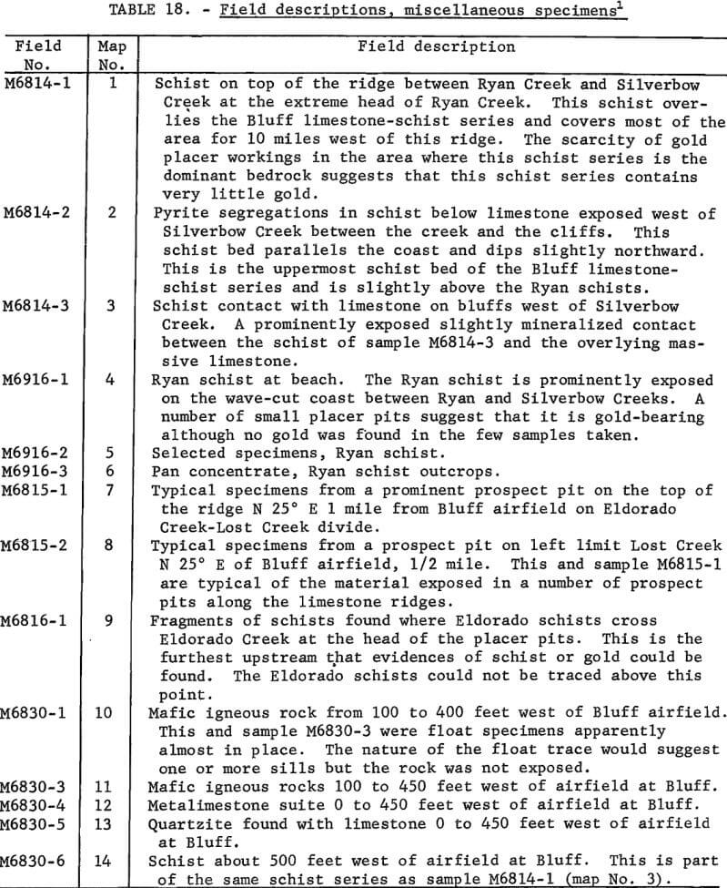
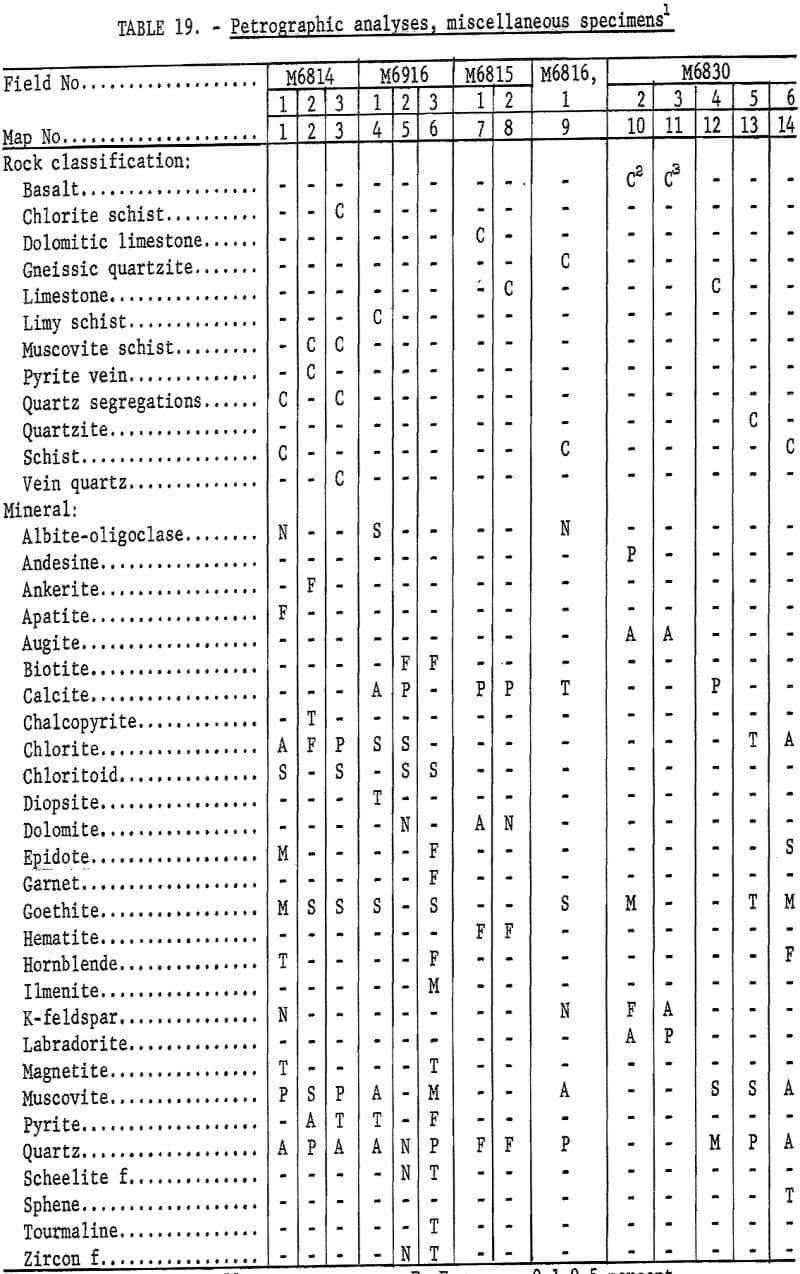
The only igneous rock found in the area were some fine to moderately coarse crystalline basalts. Rounded cobbles were found on the beaches west of Bluff, and float lines were traced inland to a source area just west of the airfield on the Eldorado Creek-Lost Creek divide (fig. 2, specimens 10-14). Possibly there are other occurrences that were not recognized. The general pattern of the basaltic material suggested a sill, but the outcrops were masked by detrital cover and vegetation. These basalts were not investigated further because sampling and study of the area revealed no relationship between the basalts and the gold deposits.
Surface Features
The dominant surface and near-surface characteristic of the Bluff area is the well-developed Karst topography, masked by erosional features typical of permanently frozen areas. Water circulation is by underground passages in limestone, except where water is forced to the surface by impervious schist beds or prevented from sinking into the ground by frozen peaty soil. A typical natural bridge is a prominent feature of the coast near Silverbow Creek; sink holes are prominent in Ryan Creek and Eldorado Creek valleys and between Eldorado Creek and Daniels Creek about 1,800 feet inland from the beach. Placer gold deposits that formed in sink holes and solution channels in limestones have received scant attention in geological and mining literature.
Work by the Bureau of Mines
Nature and Extent
This investigation was made primarily to gather data on a gold lode deposit thought to be typical of the lode sources of many of the productive Seward Peninsula gold placers. A secondary objective was to develop systematic methods for delineating and evaluating these lodes with equipment readily available in the area. The methods used were developed during the tin investigations in the western Seward Peninsula. First, the gold-bearing placers were studied in detail to determine the most probable source-areas. In these areas the detrital cover was sampled to outline the gold-bearing outcroppings and to roughly indicate the relative grade. The more favorable areas were then exposed by bulldozer trenching and sampled.
The sampling procedures and results are described as they pertain to the succeeding steps in the investigation. The placer samples and detrital cover samples were roughly evaluated in the field. All lode samples that had quantitative value were analyzed in the Bureau of Mines laboratory in Juneau, Alaska. Selected typical specimens and samples were analyzed petrographically. Petrographic descriptions are in a separate section following the description of the gold lode deposit. Sketches and maps supplement the descriptions.
Placer Investigations
The first step, after studying the general geology, was to estimate the location and relative abundance of the gold that had been in the stream placer deposits prior to mining. The objective was to estimate the general extent of the gold-bearing lode sources. The placer estimates were based on published reports, and production records checked against the size and location of placer-mining pits. This was adequate for the purpose because all the streams in the area had been prospected for gold and any deposit that showed the slightest promise had been mined. In most cases a detailed study of the abandoned placer pits, combined with a study of the production records, made the source area and the relative grade of the source area reasonably evident.
Beach Placers
The beach at the mouth of Daniels Creek (fig. 2) contained a rich deposit of placer gold that extended about 1,000 feet along the coast at approximately sea level. Wave action and later workings have obliterated most of the mining pits in this area. Occasional evidences of small-scale beach mining can be found for about 2 miles along the coast west of Daniels Creek, and traces of gold in the beach sands have been reported from as far west as the mouth of Silverbow Creek, a distance of over 3 miles. Except at the mouth of Daniels Creek, the location of beach placer workings or reported occurrences suggests that the beach placers were derived from the erosion of nearby schist beds. The more valuable beach placers at the mouth of Daniels Creek appear to have been formed by the reconcentration of stream placer material from Daniels Creek.
No evidences of valuable gold placers in elevated beach deposits have been found in the Bluff area. Rounded sands and gravel with scant traces of gold were found about 200 feet west of Daniels Creek, about 50 feet above the present beach. There also is some indefinite topographic evidence of a wave- cut terrace at this elevation. Because of the scarcity of gold, these elevated gravels were not investigated in sufficient detail to define whether they were deposited by a stream, or along a beach, or possibly by early-day mining.
Daniels Creek Placers
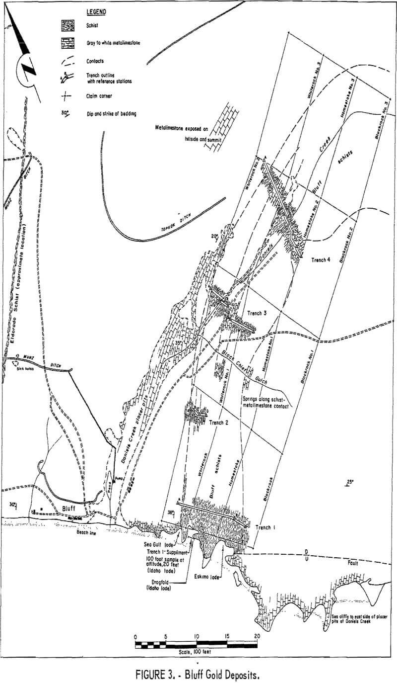
Early investigators suggested that Daniels Creek (fig. 3) followed the outcropping of a decomposed schist bed and that the Daniels Creek placers contained principally a residual concentration. Additional mining revealed that the bedrock in the placer pits is metalimestone, except at the extreme upstream end of the workings where the bedrock is schist. From the schist-limestone contact zone to the seacoast, the placer pits in metalimestone resemble a connected series of sink holes. It seems evident that the complex interlayering of clays and gravels reported by the early investigators resulted from deposition in these interconnected sink holes and solution channels. For several hundred feet inland the bedrock of the placer pits is below sea level. This, and the general water circulation pattern of the area, suggests that the channel of Daniels Creek developed when the sea was at a much
lower elevation than at present. It can be expected that for an unknown distance offshore the undersea portions of the Daniels Creek placer deposits occur in similar irregular channels in limestone.
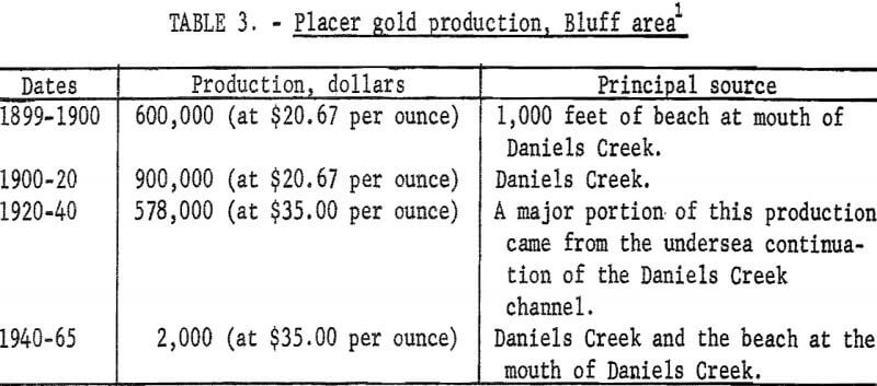
Beach placer mining at the mouth of Daniels Creek and stream placer mining in Daniels Creek, and the undersea extension of Daniels Creek produced almost all of the gold mined in the Bluff area (table 3). The upstream end of the Daniels Creek placer workings consists of a series of irregular pits that merge into lode workings in the Bluff schists. No evidence of lode gold in the limestones could be found. The placer pits deepen rapidly after the stream passes from schist to limestone; solution channels and small caverns are abundant in the limestone walls of the pits. Shaft-sinking buckets of diverse types scattered from one end of the placer workings to the other indicate that much of the recovered gold had to be dug by hand from solution channels and openings in the limestone bedrock. The placer pits with bedrock below sea level, and the seaward extension of the Daniels Creek channel probably contain gold on similar bedrock that could not be recovered with the dragline equipment used to mine below sea level.
Koyana Creek and Swede Creek Placers
The location of placer pits on both of these creeks indicates almost certainly that the gold was derived from the Bluff schists. Occasional scant traces of gold could be panned from the detrital cover overlying the Bluff schists where they cross the head of Swede Creek valley, and similar occasional scant traces of gold were panned from the detrital cover over the Bluff schists in Koyana Creek valley. The placer workings in Koyana Creek and Swede Creek valleys are comparatively shallow and of limited extent. Considering the relatively large exposure of schist in both valleys, it seems probable that the average grade of the schist exposed in these valleys is lower than in the Daniels Creek valley. Therefore, no additional work was done in either of these valleys.
Eldorado Creek Placers
Typical stream placer pits, less than 10 feet deep, with a rough limestone bedrock, extend about 3,000 feet downstream on Eldorado Creek from the outcrop of the Eldorado schists (fig. 2). Not directly connected with these stream placer workings is a remarkable 100- by 200-foot pit on the left limit of Eldorado Creek just downstream from the Eldorado schist outcrop. Apparently this pit was excavated to mine gold in a sink hole in limestone. The depth is unknown because the pit is partly filled with water and mud, but it appears to have been 30 to 50 feet or more deep.
A shaft on the east side of Eldorado Creek valley about 600 feet from the creek and about 3,500 feet inland from the beach is on or adjacent to the Eldorado schists. Placer mining equipment rather than lode equipment was found nearby. Possibly a residual concentration was mined. The Eldorado schists can be traced from the head of the placer pits on Eldorado Creek to a group of small placer pits on the beach 2,000 feet west of the mouth of Daniels Creek. Evidently they are the source of the Eldorado Creek placer deposits, although a few detrital cover samples revealed no gold. The relatively minor amount of gold produced from Eldorado Creek and the lack of gold in the detrital cover indicate that the Eldorado schists may contain gold, hut the grade probably is low. Therefore, no additional work was done in Eldorado valley.
Ryan Creek Placers
Ryan Creek is notable chiefly for the prominent sink holes in limestone downstream from the outcroppings of a thin series of schist beds called in this report the Ryan schists (fig. 2). Gold has been reported from Ryan Creek, but the few very small placer pits seen in this valley and along the adjacent sea-coast suggest that only traces have been found. A. few pan concentrates and samples taken from Ryan Creek and from detrital cover over the Ryan schists contained no gold, although the material resembled gold-bearing schists found elsewhere in the Bluff area. No additional work was done.
Detrital Cover Sampling
The study of the placer deposits in Daniels Creek and adjacent streams made it evident that the principal lode-gold deposits in the Bluff area must be in Daniels Creek valley. Numerous trenches and pits were noted throughout the valley. Although a majority of the pits were on the Bluff schists, and mineralized schist was exposed on the sea cliffs east of Daniels Creek, it was not evident that the schists were the principal source of the placer gold in Daniels Creek. This made it necessary to sample the detrital cover.
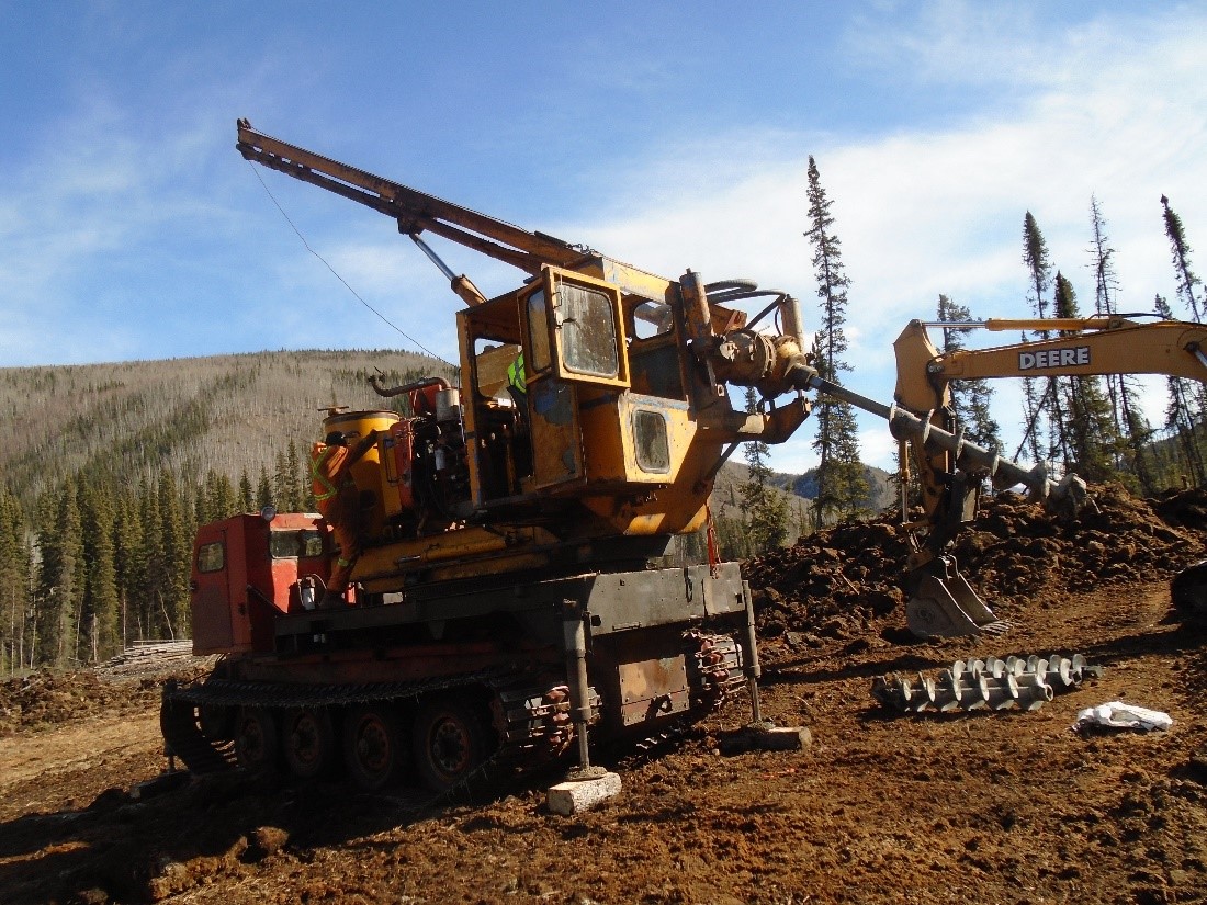
Over 300 samples of the detrital cover were taken from pits dug by hand or by gasoline-powered auger. The usual practice was to drill down to permafrost or bedrock (usually 2 to 4 feet) with a 6-inch posthole auger, stop the machine, and pull up the auger. About one 16-inch gold pan of material obtained from the scroll was the sample. The sample was first washed and screened through a gold pan in which a close pattern of 3/8-inch round holes had been drilled. The oversize was inspected for “nuggets” and discarded. Clay, soil, ice, and vegetable matter were washed from the undersize and decanted off; then the heavy minerals were concentrated by the usual panning techniques. The grade of the panned samples was estimated visually. Obviously only free gold large enough to be visible could be detected. The results were recorded as follows: 0-no gold; 1 or x-trace of gold; 2 or xx-more than a trace of gold. A more exact evaluation was found to be unnecessary. Sample sites were marked to indicate the amount of gold found. The sampling was done in an open valley to locate lode outcroppings. The sample markers made the outcrop locations evident. Mapping of sample locations was considered unnecessary.
Detrital Cover Sampling Results
Results are briefly summarized as follows:
Daniels Creek
Samples were taken at 100-foot intervals along both sides of Daniels Creek from the seacoast to the Basin Creek divide and the Swede Creek divide (fig- 2).
- Detritus derived from the erosion of metalimestones contains no gold except an occasional trace at schist contacts.
- Traces of gold were found on the west side of the placer pits at Daniels Creek associated with rounded gravels derived from schists. Apparently at some time a stream flowed on the bedrock surface. No gold was found in the detritus derived from erosion of the metalimestone hill on the west side of Daniels Creek.
- Neither gold nor schist was found in the Daniels Creek-Basin Creek divide.
- Only a few scant traces of gold were found on the east side of the placer pits from the mouth of Daniels Creek upstream 2,500 feet. For the next 2,500 feet almost every hole contained at least a trace of gold. From there to the Swede Creek divide the amount of gold decreased rapidly until only an occasional, barely discernable trace could be found.
- The Bluff schists were found to extend through the Daniels Creek-Swede Creek divide, but only an occasional, barely discernable trace of gold could be found.
Bluff Schists
The detrital cover overlying the Bluff schists was sampled from the sea-coast to the headwaters of Daniels Creek. Samples were taken at intervals of 50 to 100 feet, in rows about 500 feet apart that extended from the metalimestone on one side to the metalimestone on the other side.
- Detritus derived from metalimestone on either side of the schists contained no gold.
- Occasional traces of gold were found in the detritus overlying the Bluff schists from the coastal cliffs approximately 2,500 feet inland, but most samples contained no gold. From 2,500 to 5,000 feet inland, practically all samples taken from schistose material contained trace to minor amounts of free gold. Gold appeared to be most abundant in a zone overlying the schists and extending from 2,000 to 4,000 feet inland. Starting about 4,000 feet inland, the amount of gold diminished rapidly until only occasional traces of gold were found at the head of Daniels Creek.
Other Areas
Detrital cover samples were taken while the placer deposits in the valleys in Koyana Creek, Swede Creek, Eldorado Creek, and Ryan Creek were being examined. The results have been included with the description of these placers.
Lode Deposits
Gold Lode Workings
Gold lode workings were found in the valleys of Daniels Creek and Koyana Creek. The lode workings in Daniels Creek valley (fig. 3) include a caved adit on the Bluff cliff; more than 50 pits, trenches, and shallow timbered shafts of various ages; and the ruins of a small mill on the east bank of Daniels Creek, about 4,500 feet from the beach. Of interest also is a primitive stone arrastre on the north bank of Black Chief Gulch about 500 feet from Daniels Creek, Dumps at the shafts and at the mill are too small to indicate extensive stoping, but some gold has been produced. Apparently the ores were residual concentrations taken from pits and shafts near the old mill. The material mined from some placer pits in the same general area was, at least in part, a residual concentration on the outcrop. The lode workings in Koyana Creek valley included three caved adits and a shaft that penetrated mineralized zones in the Bluff schists; the mineralized zones were generally similar to those sampled in the Daniels Creek valley. No evidences of production were found.
Mercury Lode Workings
The only lode workings found in the Swede Creek valley, and the only mercury prospect known in the area, are a shaft and two adits about 400 feet east of the mouth of Swede Creek. The adits are on the sea cliffs about 30 to 40 feet down from the top, and the shaft is about 50 feet inland from the cliff edge. All were filled with snow when examined, and all are thought to be less than 100 feet deep. These workings apparently were excavated to explore an undulating bedding plane fault that strikes about parallel to the general trend of the coast, and dips northward 10° to 15°. Cinnabar is an occasional minor constituent of iron-stained lenses up to 5 or 10 inches thick, and a few feet long, that occur irregularly along the fault. A similar fault with smaller lenses occurs about 70 feet lower in the section, but neither deposit could be traced for over a couple of hundred feet. Cinnabar was seen in a specimen examined in the field, but samples collected for analyses contained no mercury. A rusting rotary kiln and other equipment for treating mercury ores form prominent landmarks on the hillside east of Daniels Creek. Apparently they were offloaded at Bluff for use at Swede Creek, but were never erected.
Lode Sampling Results
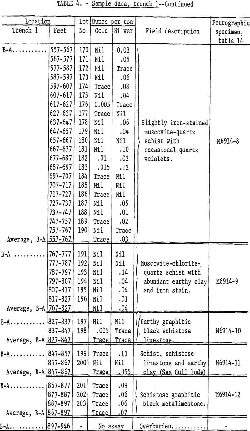
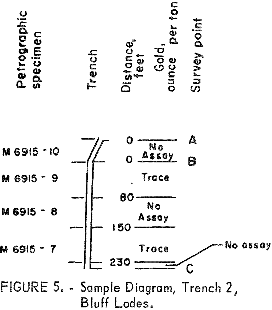
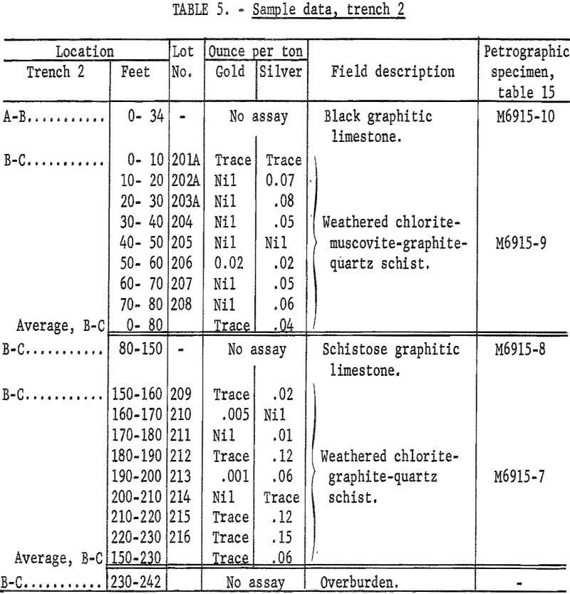
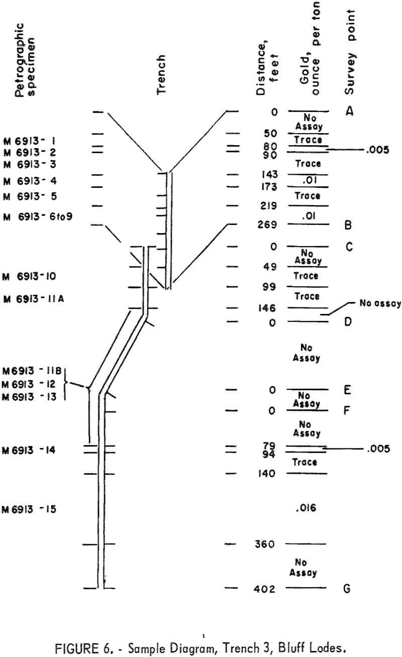
Four bulldozer trenches were excavated as shown in figure 3. Trench 1 was supplemented by a chip sample and specimens taken from the Bluff cliffs.
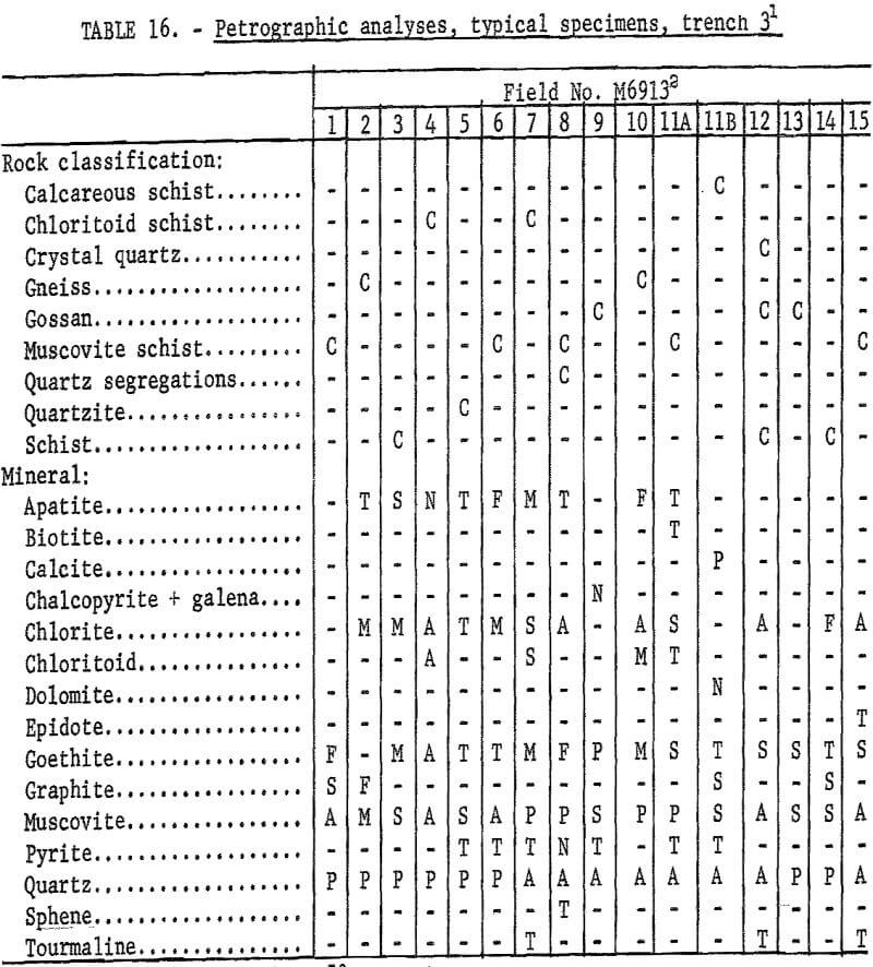
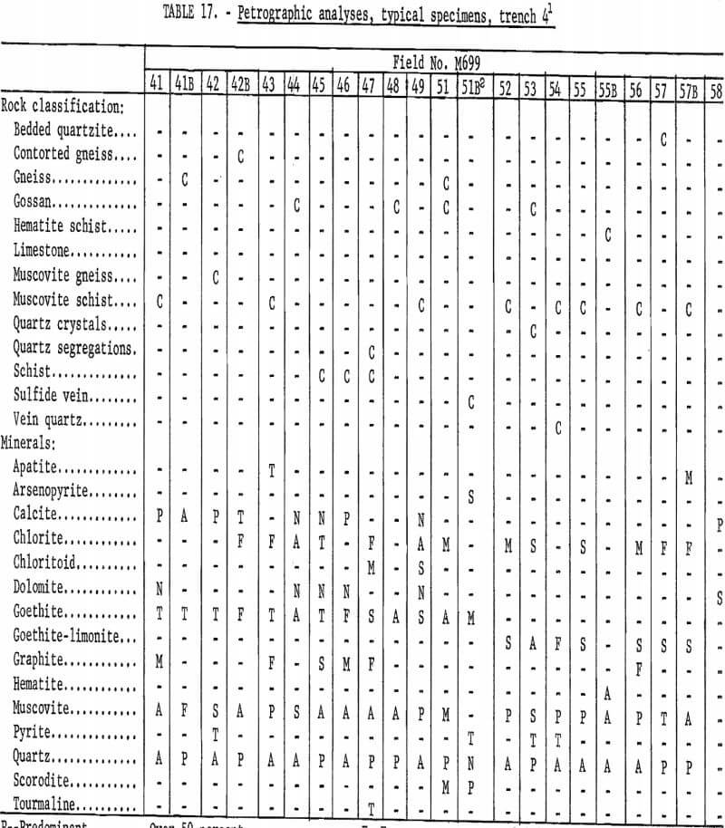
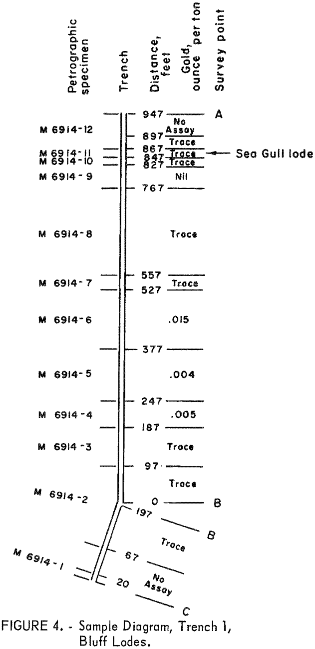
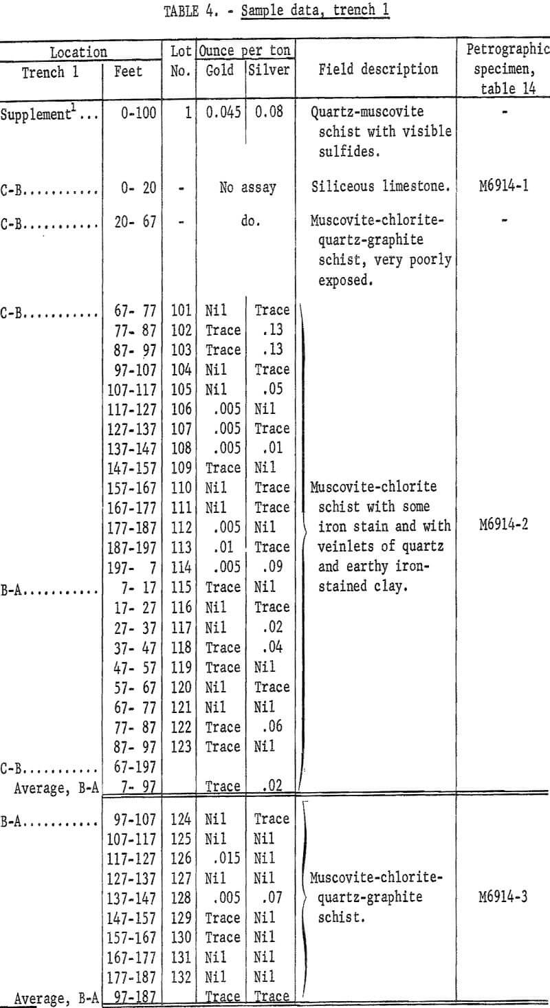
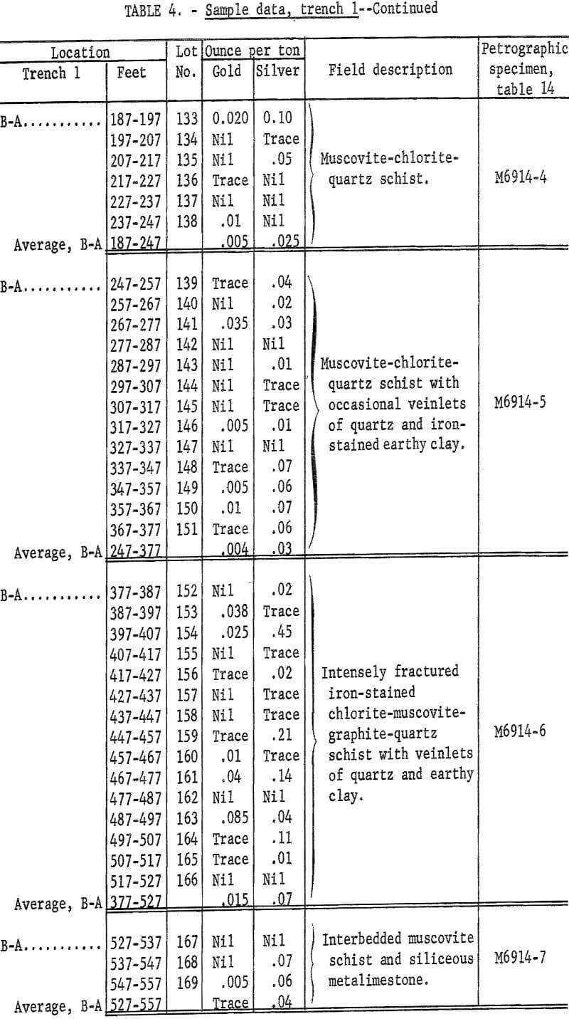
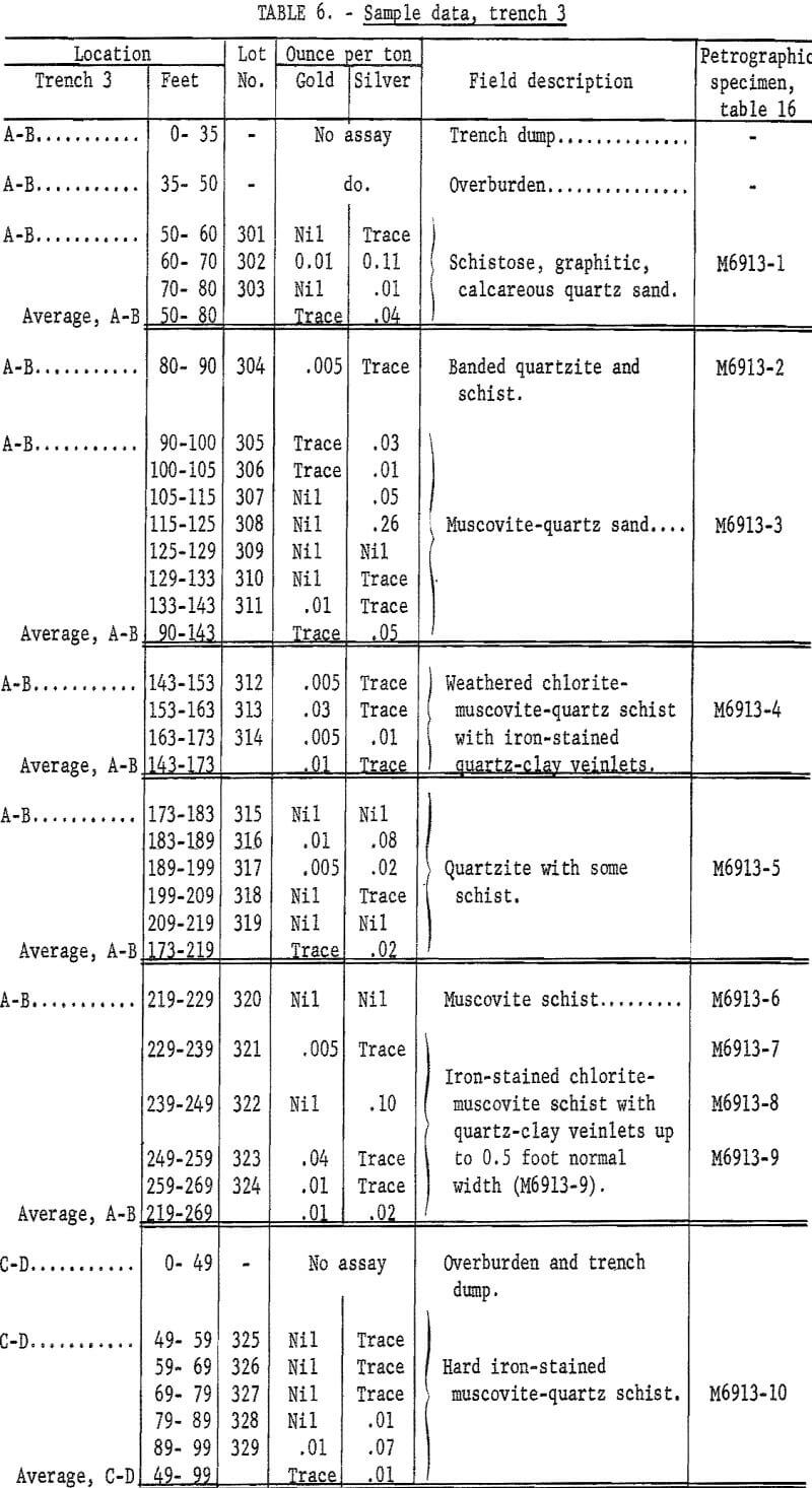
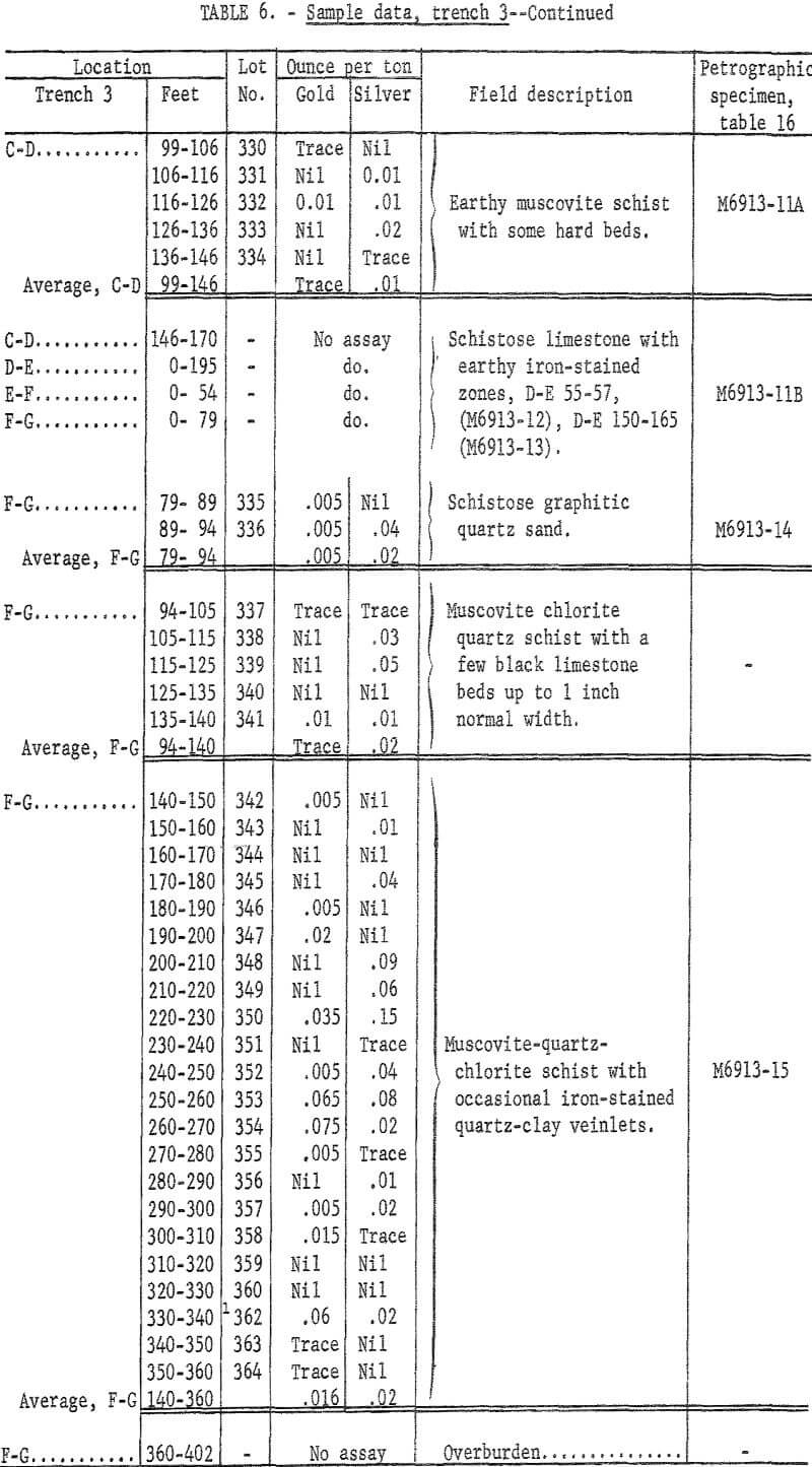
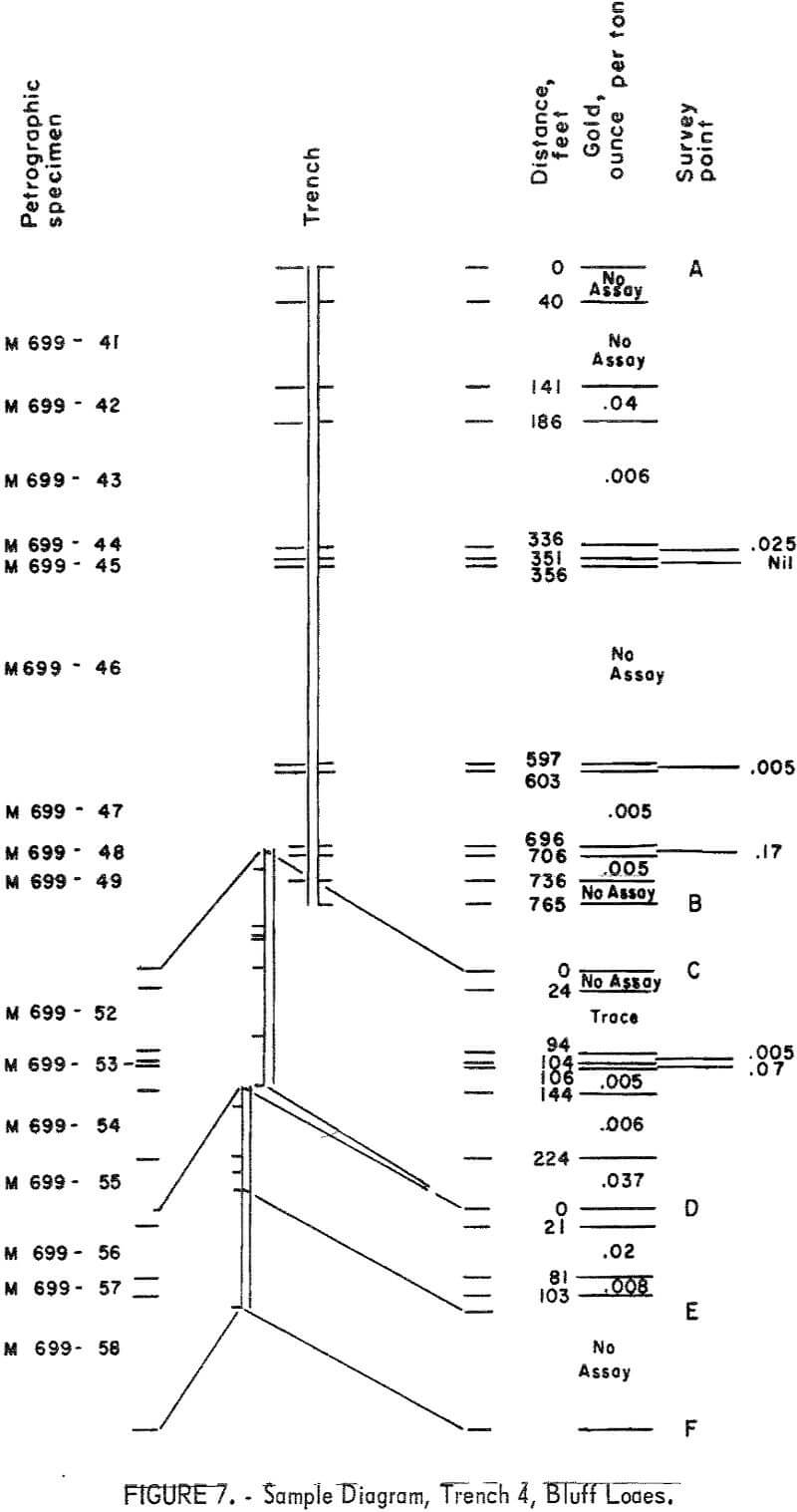
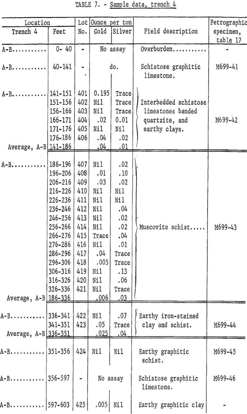
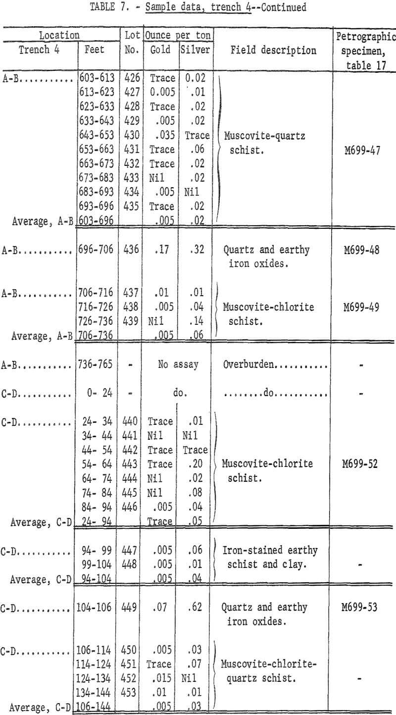
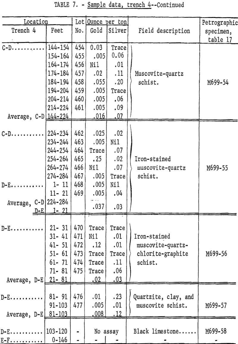
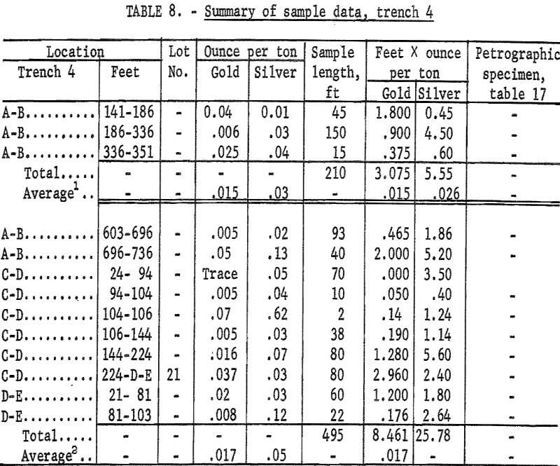
Uniform channel samples were cut in freshly cleaned bedrock on the trench bottom, each individual sample usually represented 10 feet. The individual samples are described and analyses are shown in tables 4-8. A sample diagram (figs. 4-7) precedes the tabulated data for each trench. Samples are grouped according to rock type and an average grade also is shown for each group. A field description of each type of rock is included with the tabulated data. Petrographic descriptions are in the section entitled “Petrography.”
Spectrographic Analyses
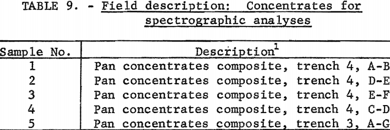
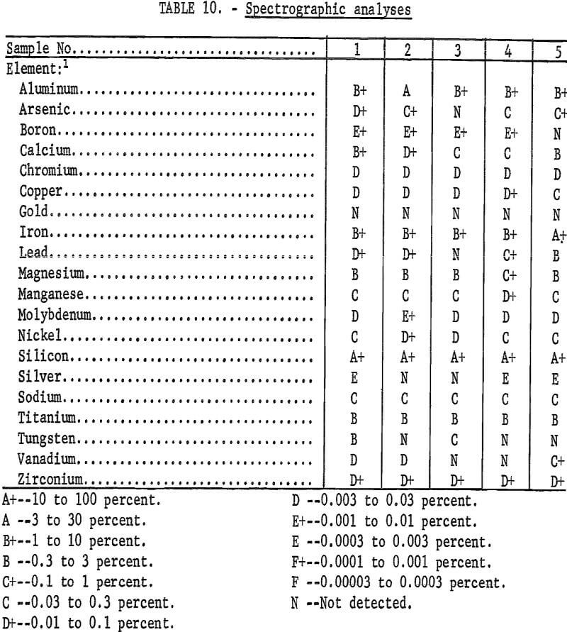
Five composite samples of concentrates panned from the detrital cover over a mineralized zone in the Bluff schists were analyzed spectrographically. Sample descriptions are in table 9; analyses results are in table 10.
Soil Sampling
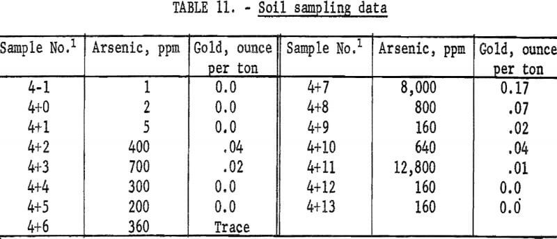
A series of 15 soil samples was taken at 100-foot intervals across a mineralized section of the Bluff schists (adjacent to trench 4, fig. 3) after the deposit had been delineated and sampled. The object was to determine if arsenic could be used as a guide to delimit the mineralized zone. Results are shown in table 11.
The gold value given is that of the nearest pertinent sample or samples. Arsenic in the soil apparently is reasonably indicative of the zone of mineralization in this deposit. The method should be tested on a larger scale on this and other deposits. There are relatively simple and reliable field tests for arsenic.
Mill Tailings
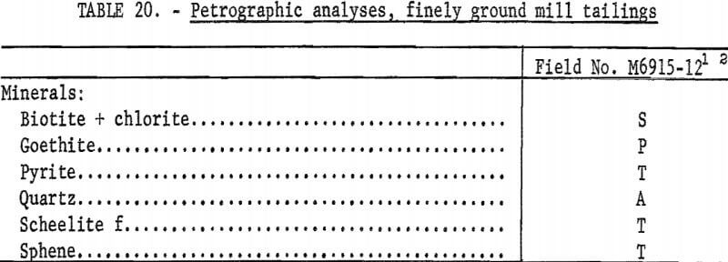
Mill tailings impounded at the old mill near trench 4 (fig. 3) were panned. No free gold or valuable byproducts were found. Laboratory analyses revealed that the tailings contain almost 10 percent arsenic intermixed with goethite. Petrographic analyses are presented in the petrographic section of this report. The specimens examined petrographically contained much less arsenic than the whole sample.
Summary
The gold placer deposits of Eldorado Creek, Daniels Creek, Swede Creek, and Koyana Creek in the Bluff area were derived from the erosion of gold lode deposits in schists. Almost all of the gold in the Bluff area placers was derived from one schist series, about 500 feet or less in normal thickness, sandwiched between massive metalimestones. The schists and the enclosing metalimestones are called the Bluff series. No evidence of gold lodes was found in the metalimestones. A thick series of schists that overlie the Bluff series and outcrop over large areas east, north, and west of Bluff produced no economically important gold placers although conditions for placer deposition seem equally favorable.
The outcroppings of the upper massive limestones of the Bluff series were traced westward along the sea cliffs to Topkok; the outcroppings then trend northwestward toward the head of the placer deposits in the Topkok-Big Hurrah-Solomon River area. Additional investigation is needed to determine if these placers derived from schists contemporaneous with the Bluff schists and occupy a similar position in the metasedimentary series.
Traces of gold are widespread in the Bluff schists, but the only gold lodes of possible economic significance occur as stockworks of interlacing minor fractures in zones of deformation that developed along folds in the sedimentary series. Stresses that resulted from bending the enclosing massive metalimestones contorted, folded, and deformed the less competent schists more or less in proportion to the intensity of folding. Part of the stockwork of fractures at Bluff contains 55 to 65 cents per ton combined gold and silver.
Additional investigation of similar zones elsewhere in the southern Seward Peninsula is needed to determine if the grade of the deposits at Bluff is typical.
The gold lode outcroppings at Bluff were readily outlined by systematically sampling the active zone in the permanently frozen detrital cover. This method should work equally well throughout northern Alaska if the outcroppings are exposed to erosion. This method probably will not be effective if the outcroppings are protected by a deep cover of loss or muck and ice.
Limited experiments on this project suggest that soil sampling with arsenic as an indicator would have been an equally effective means of outlining the gold lode outcroppings. However additional investigations are needed to determine if the use of arsenic as an indicator of gold lode deposits is generally applicable throughout the southern Seward Peninsula.
The gold lodes at Bluff are being eroded and placer deposits continue to develop at the present time. There is no reason to believe that the deposits from which the placers were derived were different from those now being eroded. Neither is there reason to believe that the remaining lodes do not extend to considerable depths. Therefore, it is logical to assume that the remaining lode reserves in the Bluff schists are at least equal to the total placer gold derived from the Bluff area (table 3). Similar assumptions may be justified in other areas in the southern Seward Peninsula but cannot be made without additional investigations.
The gold placer deposits in Daniels Creek formed in solution channels in metalimestones. Deposition in such channels explains the complex interlayering of fines and gravels reported by early-day miners. The bedrock is hard and irregular with remnant blocks, potholes, natural bridges, and tunnellike openings. An abundance of shaft sinking buckets and hand-mining equipment abandoned in the hydraulic pits suggest that much of the gold was recovered by hand mining the bedrock. In the placer deposits near the mouth of Daniels Creek, the bedrock is an unknown distance below sea level. The solution channels in the metalimestones apparently developed when sea level was much lower than at present. Therefore, the channel of Daniels Creek extends south under the sea for an unknown distance. Presumably mining conditions in the undersea portion of the channel will be much the same for an unknown distance offshore. Obviously, recovery of gold from the metalimestone section of such a channel below sea level presents serious difficulties. The unusual characteristics of this channel should be considered when interpreting drill-hole sampling data or geophysical data, and when evaluating recovery systems.
Gold placer deposits that collected in sink holes and solution channels have received scant attention in mining and geologic literature, although they were known to some prospectors. There are many sink holes in the metalimestones of the Bluff area. An isolated sink hole was mined for gold near the head of the placer pits on Eldorado Creek. Sink holes, solution channels, and other typical features of Karst erosion are common features of the southern Seward Peninsula metalimestones. However, they are not readily recognized because they are masked by a cover of silt, ice, and frost-broken debris typical of erosion in permanently frozen areas. Investigation of possible placer deposits in sink holes or solution channels might be worthwhile in other gold- bearing sections of the southern Seward Peninsula.
Petrography
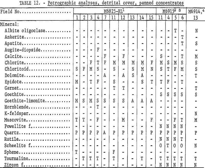
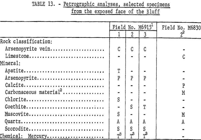
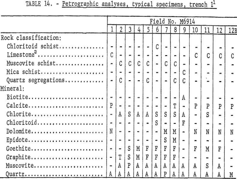
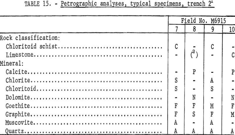
Petrographic studies were made on typical specimens of gold-bearing deposits and associated rocks. Field descriptions are in the footnotes or tabulated and mapped elsewhere as indicated by the footnotes. Two or more petrographic descriptions may be tabulated for a sample location that contains two or more distinct rock types. These are identified by an uppercase letter following the sample number; for example, M6914-12 and M6914-12B.
