 Prospectors frequently talk about being in elephant country, meaning in good hunting grounds for big deposits. Historically Carlin Type Gold Deposit are big elephants but until recently they were largely known to occur only in the limited hunting ground of Northern Nevada that limitation is now beginning to change.
How Carlin gold deposits fit into the overall scheme of things. Nature concentrates the metals by a process of partially melting Crustal rocks at the depth, letting them melt arise through the crust and on the way cool and dumping valueless minerals such as Feldspars and amphiboles and then concentrating the useful minerals and metals in the remaining magma or hydrothermal fluid. Cool, dump the dull stuff and skim off the useful materials. 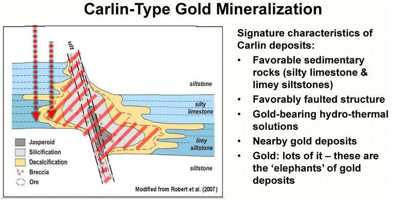 Carlin deposits are named after the little settlements of Carlin in Northeastern Nevada which is situated on the linear deposits that make up the Carlin trend where this type of deposit was first identified and where the majority of the gold currently mined in the US is derived from. Current thinking is that the Carlin deposits formed at a relatively shallow depth may be a little bit deeper than epithermal deposits but not much.
- We can define a Carlin type deposit and then giving some background into the history of Carlin deposits.
- How the West was formed.
- Understand how Carlin deposits formed and set the stage for understanding how we go about exploring for them.
- Then we run through a few typical Carlin type deposits to illustrate their salient features.
What makes it a Carlin Type Gold Deposit? There’s some confusion, sometimes about what defines Carlin style deposits. Some geologists referred to them in a sediment-hosted gold deposit and include almost any gold deposit hosted in sedimentary rocks in this grouping however I think that most geologists prefer a tighter definition. Here are some of the characteristics that define Carlin style mineralization: it’s hosted in dirty carbonated rocks; when we refer to a dirty carbonate it means a limestone that is a significant clay content and you will see later why this is it important. The gold in Carlin deposits is extremely fine-grained often just a few microns across and it’s usually enclosed within in pyrite to ion sulfide.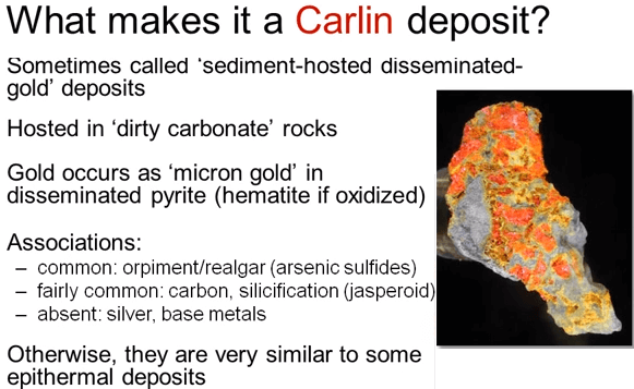 If the ore is oxidized then pyrite becomes hematite and again you will see why this is important when we refer to the history of Carlin deposits later in this course. Arsenic sulfides particularly are orange augment and are commonly associated with the mineralization. Black carbon and jasperoid or red brown silica also common but silver and base metals are rare, these are essentially gold only deposits.
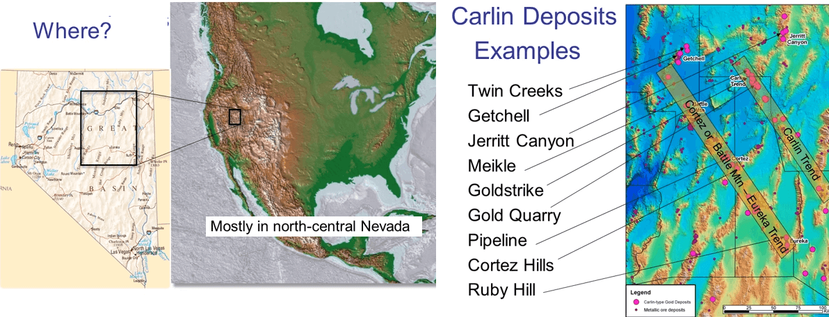
Where are Carlin deposits found? If you’d asked me this question a couple of years ago my answer would’ve been virtually only in Northern Nevada. There was a similar occurrence in Argentina and some deposits in China that had been classified as Carlin deposits but none of the ones that I have seen there truly fitted the requirements. What has changed in the last couple of years is the discovery of what is almost certainly Carlin type mineralization in the Yukon. ATAC’s Osiris and Conrad targets seem to fit all the requirements to be classified as Carlin type deposits. How extensive and widespread the Yukon deposits will turn out to be will not be known for many years yet but I think it’s still fairly safe to say that the vast majority of Carlin deposits occur in Northern Nevada which is why I earlier referred to them as being big elephants but within a limited hunting ground. Not only are they mostly restricted to Northern Nevada but the majority of the Carlin deposits are constrained to two narrow sub-parallel corridors: The Carlin trend and the Cortez or Battle Mountain Eureka trend. You can see these highlighted in the digital elevation map. The known Carlin deposits are marked as magenta circles, the size reflecting the size of their resources. As you can see there are a couple of smaller trends and other single deposits scattered around the Northern part of the state but the recognized trends are key. They are the source of much of the 19 million oz. that have been produced from Carlin deposits to date.
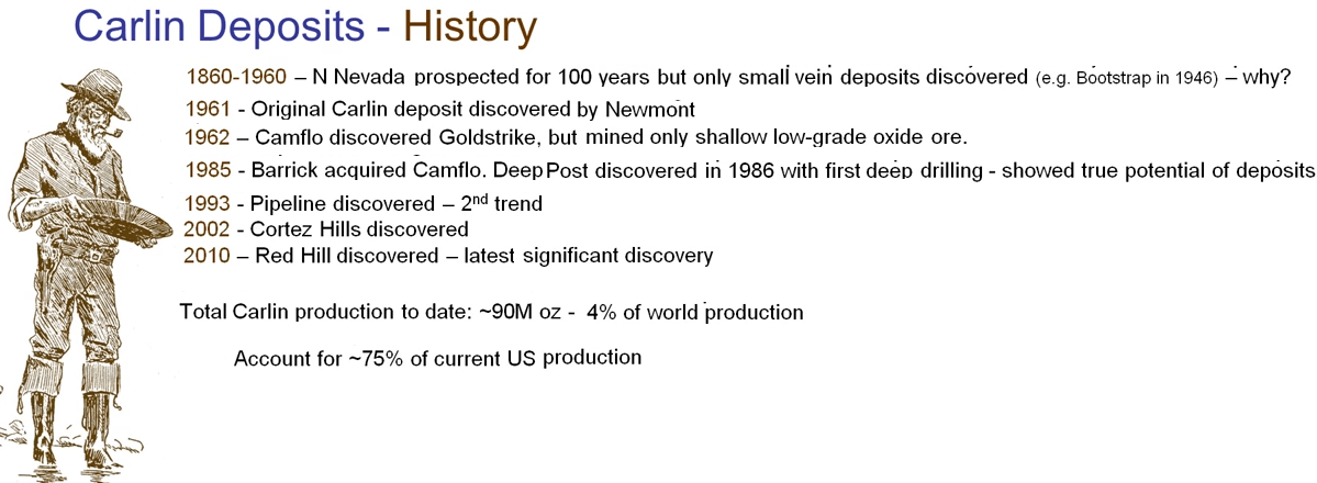
Carlin deposits have an interesting history because the first one of this deposit group was discovered only in 1961 in spite of Northern Nevada having been crisscrossed by prospectors for over 100 years. The prospect has found the younger epithermal veins but they relied on panning gold as a prospecting method. The fact that gold grains only a few microns across are invisible to the naked eye and often even floats on water meant that the old time prospectors walked right over the Carlin deposits.
- After Newmont discovered the original Carlin deposit in 1961 there was a long period when only heat bleachable oxides ores were mine, the sulfide ores refractory and expensive to treat.
- In 1986 Barrick took the plunge and drilled some deep holes under their precipice and recognized the depth extent and higher grade sulfide ores only then did they gain the confidence to go after these primary deposits.
It was a pivotal decision as I said that the total Carlin production to date is 19 million oz. and that’s about 4% of the world production and more than 75% for the current US production.
So what is it about Carlin deposit that makes them so attractive:
- Carlin deposits can be very big gold strikes us over 14 million oz. of gold in production and reserves. Quarters Hills has reserved nearly 15,000,000 oz. the primary sulfide ore can also be very high-grade and grades of several ounces per ton are regularly intersected in drilling.
- Shadow ore is usually oxidized and it is simple and cheap to extract the gold in oxide ores.
- Because of their size they can often be mined by open pit without prohibitive stripping ratios strip being the ratios. Open pit mining cost a fraction of underground mining but as deposits get deeper we can expect to see more and more mining of Carlin deposits from underground. Due to a combination of these factors the economic cutoff for Carlin deposits have been low often less than 0.2 of gram per ton of gold in oxide pits.
- Carlin deposits are attractive for both Nevada and the Yukon are politically stable although the ever increasing legislative pressure on exploration and mining is a major impediment in Nevada.
How Nevada and the Western half of North America were formed. We will cover some 3 billion years of history in just 15 minutes and we start with the formation of one of the oldest continental crust in the world an Archean granite greensand craton that formed between 3.4 and 2.7 billion years ago. Following that there was a long period almost 50% of the earth’s entire history that does not really concern us too much. Under the influence of plate tectonics all sorts of stuff happened during this period, continents clumped together and split apart and then rejoined again to form the supercontinent of Rodinia. Volcanic and sediments were deposited over the Archean crust that was destined to become Western North America but by 650MA; geologist usually abbreviated million years to MA, by 650MA most of these cover rocks had been eroded at least from what was to become Nevada. At 650MA the supercontinent split again with Australia and Antarctica been torn off North America along pre-existing faults and the Pacific Ocean opened up along the West Coast of North America.
Lets now focus on the last billion years or 25% of earth’s history. At one billion or 350MA before Australia and Antarctica were torn away most of Nevada was below sea level, California didn’t even exist and significant dry land only began in Utah. Keep an eye on the gray lines showing the outlines of the future West Coast of North America and the state of Nevada as we step through time. The time is shown at the bottom of the screen.
Now fast-forward to 650MA the Pacific Ocean has begun to open and Australia and Antarctica have sailed away into the sunset. California is represented by just a few fragments of Antarctica that broke off during the rifting event and were left behind.
Most of Nevada is still well below sea level and sediments are accumulating on the new sea floor. The edge of the North American continent is marked as a yellow line running north-south through the center of Nevada with shallow water continental shelf to the east of the yellow line and deeper oceanic basin to the West. This new continental margin plays an important role in the genesis of the Carlin deposits.
By 500MA on the shallow water continental shelf where there is enough light available for corals to survive thick layers of limestones and dolomites with varying amounts of clay are being deposited. Off the shelf to the West in deeper water only muds and fine-grained sands are accumulating the products of erosion of the continental fragments and the mainland.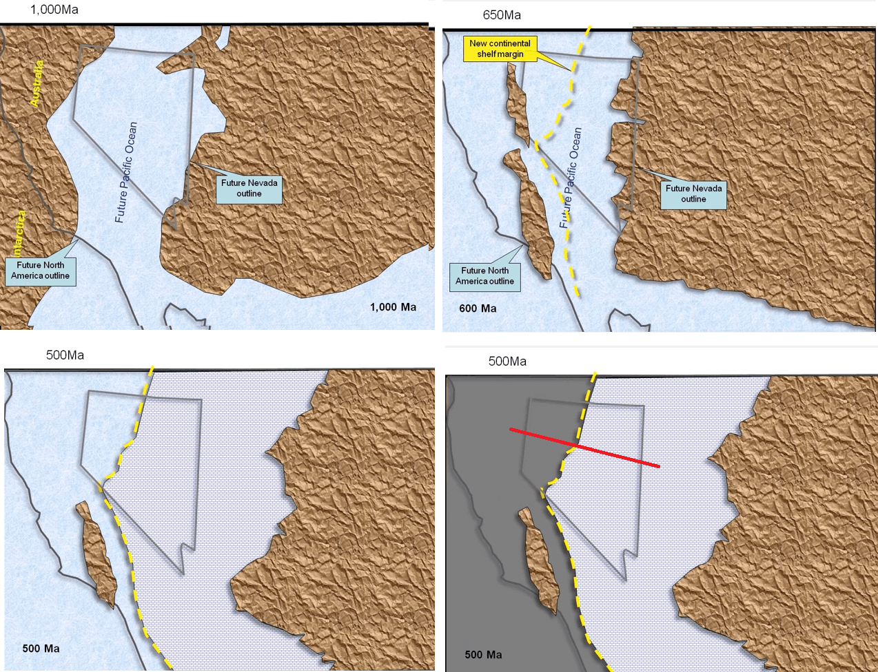
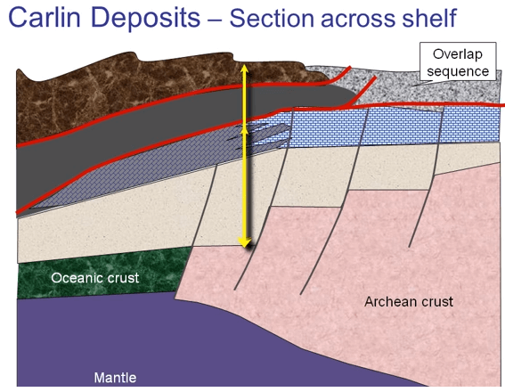
If we were to draw an east-west cross section across the red line it would look something like this, the section is vertically exaggerated for clarity. 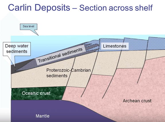 You can see the pink Archaean crust joining the new formed green oceanic crust and overlaying by their early buff colored sediments that were laid down during and immediately after the rifting that formed the Pacific Ocean. The limestones are forming on the shelf and deep water mudstones to the west. There is a transitional shelf edge zone where the two fingers transformed.
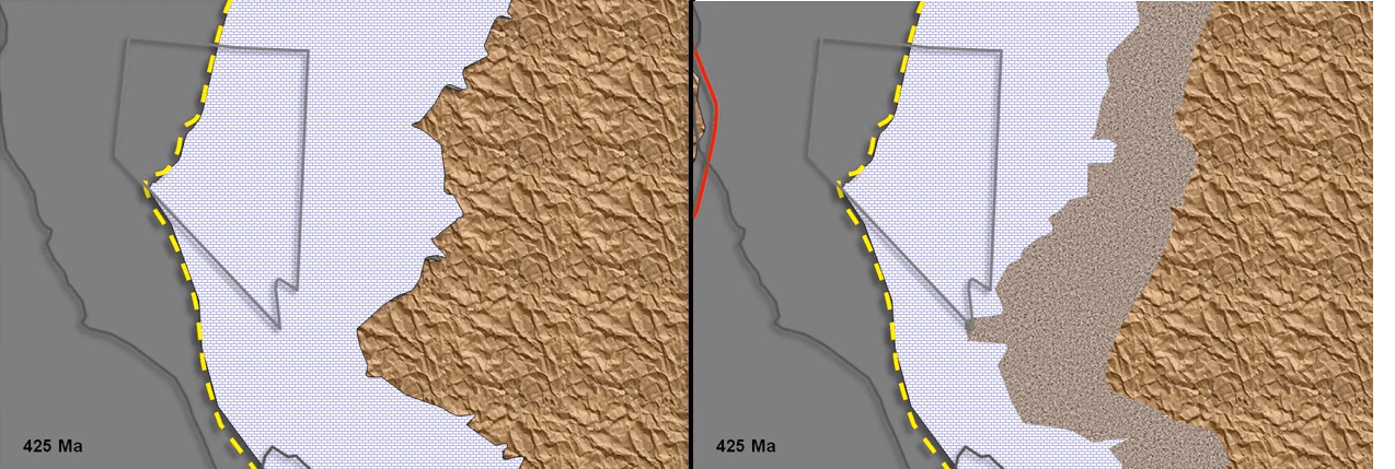 By 425MA the typography along the coast of our present day Colorado and Utah has been eroded down and re-deposited as thick mudstones offshore however this quiet period is about to end as a new subduction zone forms out in the Pacific ocean. Oceanic crust begins to be pulled Eastwards and slipping under the North American continent and riding on this plate of oceanic crust is a volcanic arc that is rapidly approaching the continent.
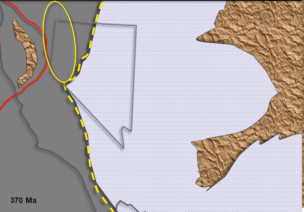
By 370MA the volcanic arc as reached the edge of the continental shelf bulldozing the deep water mudstones ahead of it folding and contorting them as it goes. This is the beginning of the so called ontogeny which plays an important role in the tectonics of Nevada. If we go back to our cartoon east-west section again the process looks like this; volcanic arc is approaching from the left, bulldozing the deep water sediments ahead of it and pushing those deep water sediments up the continental slope and onto the continental shelf, the pressure from the shelf causes the old extensional faults that formed when the continent is ripped apart to invert or reverse direction. That’s continued to push eastward towards the shallow shelf riding on a thrust fault known as the Roberts Mountain thrust.The deep water sediments above the thrust are collectively known as the upper plate while the carbonate and transitional rocks below the thrust are known as lower plate rocks. The pile rises above sea level and starts to erode dumping course sediments known as the overlap sequence in front of it. The upper plate subsequently overrides this overlap sequence.
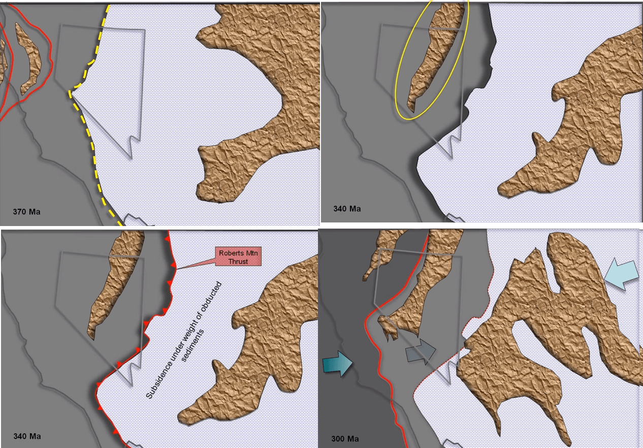
Okay back to the pterodactyls’ view of our evolving coastline. By 340MA those deep water sediments that are being pushed onto the shelf produces a new mountain chain that is broken surface to form an elongated island that is now being eroded. This new mountain chain straddles modern-day Nevada and the area of the Carlin and Cortez gold corridors. The Roberts Mountain thrust breaches the sea floor along the eastern margin of those abducted deep water sediments. The continental shelf to the east of the thrust sags due to the weight of the sediments and the coastline retreats eastward with extensive limestones continuing to form in the warm and shallow seas.
By 300MA the strain on the oceanic plate due to the pushing of the mass of deep water sediments over the shelf causes the oceanic plate to break well to the west of the bulldozed sediments and subduction continues along this new break sliding at a very flat angle under the shelf to coast and beyond and the Utah. Concurrently on the East Coast of North America the North Atlantic Ocean closes and Europe slams into the East Coast forming the Appalachian Mountains. The compression from both the East and the West causes the center of North America to buckle pushing up the Ancestral Rocky Mountains. This is what the process looks like along our east-west section across California, Nevada and Utah you can see the new slab of oceanic materials subducting under the continent. Then the slab continues to disappear down the subduction zone and into the mantle. The sediments and volcanic arcs that are being deposited on the ocean floor are being scraped off the plate and piled on top of the upper plate sediments. These new piles of debris slide on newly developed thrust faults similar to the Roberts Mountain thrust and they move the wedge of sedimentary material eastward over the continent and well into Utah.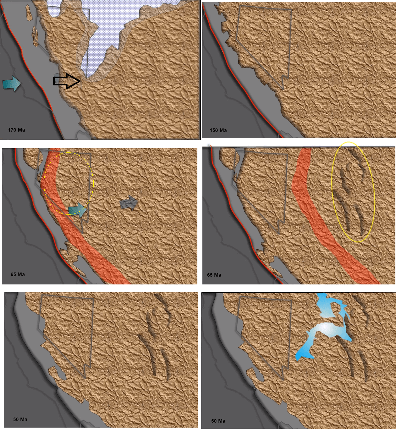
By 170MA continued eastward subduction of the Pacific Ocean plate causes more volcanic arcs to collide with continent. This Nevada orogeny results in another phase of thrusting across Nevada by this time the subducting Pacific Ocean plate has lifted almost all of Nevada well above sea level and by 150MA the whole of Nevada and Western Utah form parts of an extensive high plateau. The ocean to the east and the center of the continent has disappeared altogether to reveal sandy and muddy sediments that have accumulated on the erosion of the Ancestral Rocky Mountains.
At 65MA eastwards subduction is still continuing and compression and thrusting and crustal thickening continue over Nevada and Utah the subducting plate melts as it slides under the continent resulting magma rises up through the crust to form an extensive intrusion and volcanic activity along the West Coast of North America. The massive granites of the Sierra Nevada Mountains form as the core of this magmatic event. The flat subducting plate continues to force its way eastward under the continent and the volcanic arc follows just behind as the eastward advancing edge.
By 55MA the eastern edge as reached halfway across Colorado raising the Rocky Mountains in the so called Laramite orogeny. When the eastern edge of the plate reaches where Denver now stands the spreading ridge of the oceanic plate is subducted and subduction of the Pacific plate abruptly halts. After 320 million years of being under continuous compression on the repeated collisions of volcanic arc rafted in on the Pacific plate North America suddenly goes quiet, thrusting has stopped, subduction and the related volcanic activity have ceased and placid lakes begin to form and sags over Utah but this period does not last long. Beneath the continent the relatively cool slab of subducted oceanic crust that is insulated the overlying Nevada from the heat of the mantle is rapidly approaching melting point.
 At about 42MA this heat shield burns through and hot mantle is once again in direct contact with the lower crust; all hell is about to break loose and the Carlin deposits are about to come into being.
 You can see that subducted oceanic plate melting and exposing the lower crust to the heat of the mantle. For the last 600+ million years the Western US crust has been constantly thickened, firstly by thousands of meters of sediments being deposited on the shelf of an oceanic floor and then for the last 320 million years thrusting has doubled the thickness of sediments and seeing huge volumes of intrusive introduced because the crust is being under compression this buildup has been sustainable with the base of the crust sinking into the underlined mantle.
If you read the introductory geology course in the series of geology and exploration courses you may remember this slide showing how the relatively light continental crust floats on top of the denser mantle like a raft on water. 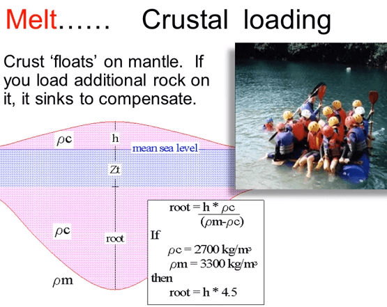 Load more people on top and the raft simply displaces an equivalent weight of water and keeps on floating albeit just a little bit lower. In the Nevada the underlined raft of continental crust that is being protected by the cool underlying oceanic slab is suddenly exposed to the very hot mantle and this blast of heat causes the base of the crust that is supported the high plateau of Nevada to rapidly melt. The strong foundation that the sedimentary pile was built on suddenly loses its strength and like cheese placed on top of a hot hamburger a large portion of the Southwestern US simply collapses relaxing along the original faults and spreading westwards away from the center of the continent. Here you can see the lower crust partial melting and the original faults and thrust both deep and shallowly dipping going into extension, this process began at approximately 42MA.
  The partial melt from the base of the crust is enriched in gold in the same way as the partial melt described in my talk on green stone belt deposits and because it’s hotter and less dense in the crust above it the melt rises through the crust taking advantage of the old faults that are being re-mobilized as the pressure drops the aqueous fluid separate out and rise ahead of the melt. Closer still to the surface the gases from the fluids forming a hot and acid vapor that rapidly spreads ahead of the rising fluid permeating even the finest cracks and into granular spaces.
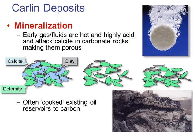 When these hot acid vapors reach the limestones they attack the calcite dissolving it in a similar way to antacid tablets dissolving in water but remember that these limestones are not pure clean calcites, they are made up of a mix of grains of calcites, dolomite and clay. Whereas the calcite readily dissolves in the dilute acid the dolomite and clay does not, what is left after the calcite is gone is for porous latus of dolomite and clay. This latus partially collapses under the weight of the overlying rock but it still remains for porous when the gold bearing neutral pH fluids catch up and the fluids can readily pass through this newly created sponge.
 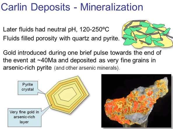 Secondary result of this hot vapor and fluids is that any oil that is trapped in the oil reservoirs tends to get cooked and turned to carbon. Black carbon is a very common feature in Carlin type gold deposits. The neutral pH fluids begin to deposit quartz and pyrite in the pores of the altered rock. The early fluids contain little gold but late in the process there is a pulse of fluid that is highly enriched in arsenic and gold. The gold drops out of the solution along with arsenic forming a rim around the earlier performed pyrite grains then gold is exhausted and only arsenic is deposited as the system cools and wanes depositing red realgar and yellow. Although the gold pulse is very short lived it is responsible for the vast majority of the gold mined in Nevada.
This is probably a good time to talk briefly about how the gold is extracted from Carlin ores. If the ore has been subjected to weathering the pyrite is oxidized to pores hematite and cyanide solutions used in extraction can come into contact with the fine gold and dissolve it. Oxide ores can be easily treated with standard carbon circuits or it even heat bleached. This makes extraction cheap and simple a big advantage of a shallow weathered ore deposit however if the ore has not been weathered the gold is locked up in the pyrite grains which then have to be oxidized artificially to break down the pyrite to hematite. 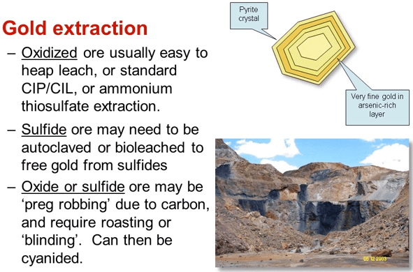 This is usually done by roasting or using an autoclave which is basically an industrial scale pressure cooker it’s well proven technology but expensive in terms both of initial capital and operating cost. In addition the presence of carbon in the ore is a complication. When the gold is released from the pyrite and dissolved by the cyanide it tends to bind with the carbon and you’re back to square one. Sulfide ores with carbon are sometimes referred to as being doubly refractory and require the addition of a reagent to prevent the gold from binding to the carbon, as the mineralizing fluids rise up their feeder faults through the sedimentary layers they bleed out into those layers that are particularly porous and reactive.
 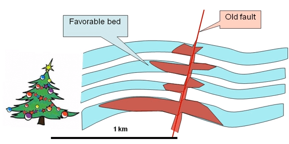 Carlin deposits are sometimes described as being Christmas tree shaped and stacked or horizons are common. Exploration therefore requires an understanding of both the local structure and the stratigraphy.
So that is a quick arc line of how Carlin deposits are formed but it is not quite the end of the story as the collapse of the Nevada crust continuing after the deposits have formed and in fact the extension is still continuing today 40 million years later. The existing faults and a whole series of new faults continue to move both displacing and breaking up the ore deposits. In addition the faulting formed a series of mountain ranges separated by sinking valleys, the so-called basin and range typography. Erosion removed parts of the mountain ranges and deposited the debris in the adjacent valleys in places bearing the host rocks under up to 20,000 feet of gravels. This obviously makes exploration highly challenging.
This is not the type of deposit mined using a gold trommel. All Carlin deposits need rock crushers and deep ball milling acting as pulverizers.


